


- Quicktime (.mov) format (628 KB)
- MPEG-1 (.mpg) format (1.5 MB)
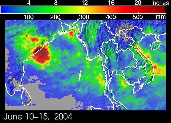
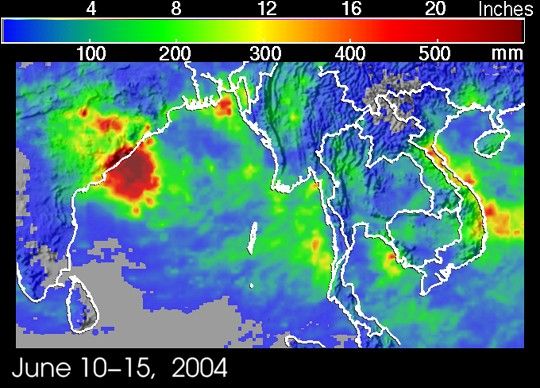
Two separate weather events brought disaster and flooding to parts ofsouthern Asia. On the 12th of June 2004, tropical storm Chanthu becamea typhoon in the South China Sea and came ashore over central Vietnam.The storm left seven people dead, mostly fishermen, and seven more missing.At the same time, a strong monsoon depression in the Bay of Bengal wreckedhavoc on local fishermen. The storm generated large waves that capsizednumerous fishing boats. At least 14 fishermen drowned with many morestill unaccounted for. The depression then passed over the east coast ofIndia dumping torrential rains along the coast.
The Tropical Rainfall Measuring Mission satellite, launched inNovember 1997, uses both passive and active sensors to measure rainfallover the global tropics from space. The TRMM-based, near-real time Multi-satellite Precipitation Analysis (MPA) at the NASA Goddard Space FlightCenter provides quantitative rainfall estimates over the global tropics.MPA rainfall totals are shown for the period 10-15 June 2004 from centralIndia through the Indo-China peninsula. Scattered red areas along thecoast of Vietnam indicate rainfall totals in excess of 14 inches as aresult of Typhoon Chanthu. Meanwhile, the large red area along the eastcoast of India shows were between 16 and 24 inches of rain (darker redareas) fell as a result of the monsoon depression.
References & Resources
Images produced by Hal Pierce (SSAI/NASA GSFC) and caption by Steve Lang (SSAI/NASA GSFC), NASA's Tropical Rainfall Measuring Mission.