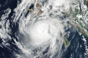
On June 12, 2019, Tropical Cyclone Vayu was barreling towards the western coast of India with sustained winds of 170 kilometers (110 miles) per hour. The storm spurred nearly 300,000 people to evacuate their homes in advance of what might have been the worst storm to strike Gujarat in 20 years. But then the storm changed direction.
This image shows Vayu off the coast of Gujarat state on June 13, 2019, before veering west towards Oman. The image was acquired by the Visible Infrared Imaging Radiometer Suite (VIIRS) on the Suomi NPP satellite.
Although Vayu did not make landfall in India, gusty winds and rain from the edges of the cyclone knocked down trees and cut power in some areas. Strong winds and surging waves also damaged a 150-year-old temple near the city of Porbandar.
Some forecasters say the rains may bring some relief to the region, which has been experiencing a delayed monsoon season and record-high temperatures.
References & Resources
- AccuWeather (2019, June 13) Cyclone Vayu spares India coast a direct hit, may bring some pre-monsoon rain to Delhi. Accessed June 13, 2019.
- Local10 (2019, June 12) 300,000 evacuated in India ahead of Tropical Cyclone Vayu. Accessed June 13, 2019.
- India Meteorological Department (2019, June 13) Cyclone Warning for Gujarat Coast: Orange Message. Accessed June 13, 2019.
- India Today (2019, June 14) Cyclone Vayu to not make landfall at Gujarat coast, confirms IMD. Accessed June 13, 2019.
NASA Earth Observatory image by Kasha Patel, using VIIRS data from NASA EOSDIS/LANCE and GIBS/Worldview, and the Suomi National Polar-orbiting Partnership. Caption by Kasha Patel.