Editor’s Note: This Image of the Day is the answer to the December Puzzler.
Where can you find rare shrub bogs, red wolves, black bears, bomb targets, ghost forests, and salt water intrusion in one place? Answer: North Carolina’s marshy Albemarle-Pamlico Peninsula, home of Alligator River National Wildlife Refuge.
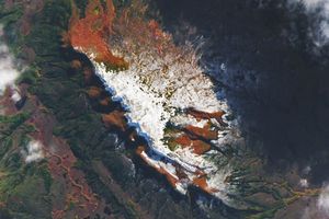
The Operational Land Imager (OLI) on Landsat 8 acquired this natural-color image of the refuge on November 25, 2019. The geometric patterns in the middle of the image are caused by the layout of roads, drainage canals, and targets within Dare County Range, a military site managed by the U.S. Navy and U.S. Air Force.
The bombing range and surrounding wildlife refuge protect an unusual freshwater shrub bog habitat called pocosin. The name is derived from an Algonquian word meaning “swamp on a hill.” Pocosin vegetation grows on slightly elevated patches of peat, a carbon-rich type of soil that sops up rain water and slowly releases it over time.
The refuge is home to the world’s only population of red wolves. Though the species was declared extinct in the wild in 1980, biologists began to transfer red wolves bred in captivity to the refuge in 1987 in an attempt to reestablish a wild population. About 40 wolves survive in the refuge today, along with one of the most concentrated populations of black bears in the southeastern United States. Both of these species—and many others—make use of the pocosin forests and shrubs that thrive on the peninsula. Common plants in pocosin bogs include pond pines, bitter gallberry, and fetterbush.
Pocosin ecosystems in this area were disappearing quickly in the 1980s because of logging and the spread of drainage canals for farms. Now that the wildlife refuge prevents new development, rising seas and saltwater intrusion are the biggest threat to the health of the peninsula’s pocosin. With some of the fastest rates of sea level rise in the eastern United States and the regular passage of hurricanes, researchers have found that salt water is getting pushed up networks of drainage canals on the peninsula at an increasing frequency and harming vegetation.
Some parts of the refuge have lost 70 percent of their trees since the 1980s, leaving growing swaths of “ghost forests.” An interdisciplinary team of scientists from North Carolina State University and Duke University has been mining decades of satellite data and conducting experiments in the field to better understand the processes that are killing so many trees. Their research shows that forest loss has been particularly pronounced after droughts and hurricanes. On the ground, the changes are “dramatic,” the refuge’s manager, Scott Lanier, told Coastal Review Online.
References & Resources
- Air Combat Command (2010, October 14) Range offers vast array of considerations. Accessed December 27, 2019.
- Albermarle-Pamlico A to Z in the Albemarle-Pamlico Estuary. Accessed December 27, 2019.
- ArcGIS Story Maps (2019, July 26) Whatâs happening to these forests? Accessed December 27, 2019.
- Coastal Review Online (2019, July 31) Visible Change: Alligator River âGhost Forests.â Accessed December 27, 2019.
- Duke University (2019) Detecting and Predicting Impacts of Saltwater Intrusion on Coastal Ecosystems. Accessed December 27, 2019.
- North Carolina Sea Grant (2019) The Ghost Hunters. Accessed December 27, 2019.
- North Carolina State University Land-use and land-cover change on the Albemarle-Pamlico Peninsula. Accessed December 27, 2019.
- Science Friday (2019, May 17) The Ghost Forests Of North Carolina. Accessed December 27, 2019.
- U.S. Air Force Dare County Bombing Range. Accessed December 27, 2019.
- U.S. Department of the Navy (2015) Range Air Installations Compatible Use Zones Study for the Navy Dare County Bombing Range Complex. Accessed December 27, 2019.
- U.S. Fish & Wildlife Service Habitat Types. Accessed December 27, 2019.
NASA Earth Observatory images by Joshua Stevens, using Landsat data from the U.S. Geological Survey. Story by Adam Voiland.