


March 27, 2021
Traffic Jam on the Suez Canal
One of the world’s most important shipping lanes—the Suez Canal—is reopening this week. But as satellite imagery shows, the traffic jammed up around the canal’s two ends is substantial and is likely to take some time to disperse.
After a grounded container ship blocked traffic on the Suez Canal for six days, the key shipping route through Egypt reopened on March 29, 2021. Engineers were aided by a natural process—a high spring tide—in their efforts to dislodge the massive ship with tugboats, dredging equipment, and backhoes.
Spring tides occur when tides "spring forth" during new and full moons—when the Earth, Sun, and Moon are in alignment. In this case, the tides in the Suez Canal rose about 46 centimeters (18 inches) above normal on March 29. That made it slightly easier to refloat and straighten out the ship. After being dislodged, the ship continued north into Great Bitter Lake, a wider part of the Suez Canal system.
While ship traffic began moving through the canal again on March 29, it will take some time to clear the queue of waiting ships. As of March 28, the canal service company Leth Agencies reported 367 ships were waiting to pass through the canal. The company said that 154 were waiting to the north near Port Said; 42 were in Great Bitter Lake; and 171 were south of stranded ship in the Red Sea.
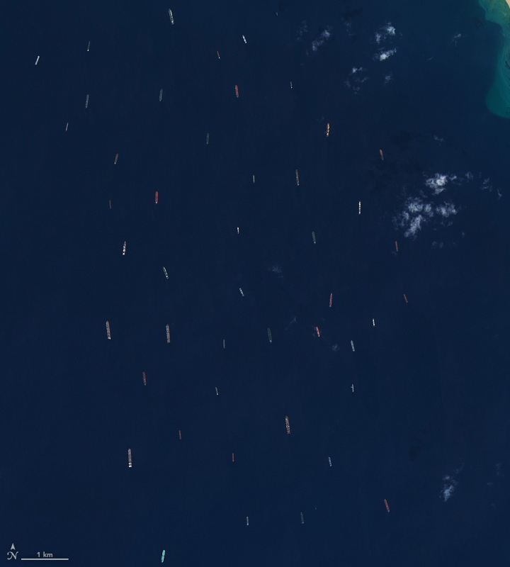
On March 27, 2021, the Operational Land Imager (OLI) on Landsat 8 acquired an image of the many ships waiting ships in the Gulf of Suez, the northwestern arm of the Red Sea. For comparison, the second image shows the area on March 11, 2021. Among the ships in the queue: container and cargo carriers, crude oil tankers, and chemical tankers. It could take up to three days to clear the backlog, according to the Suez Canal Authority.
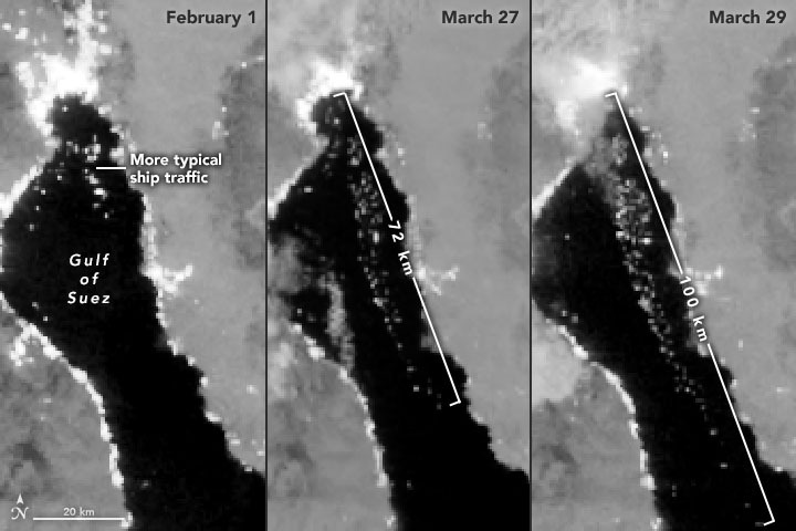
The series of nighttime images above, all acquired with the Visible Infrared Imaging Radiometer Suite (VIIRS) on the Suomi NPP satellite, offers another view of ships waiting in the Gulf of Suez. The VIIRS “day-night band” detects light in a range of wavelengths from green to near-infrared and uses filtering techniques to enhance dim signals such as moonlight, gas flares, and the lights on ships. The left image shows typical ship traffic in the Gulf of Suez on February 1, 2021. By March 27, the line of waiting ships stretched 72 kilometers (45 miles). Two days later, ships waited as far as 100 kilometers (60 miles) from the canal entry. According to Leth Agencies, 184 vessels were still waiting to get through on March 30.
References & Resources
- Leth Agencies (2021, March 29) Latest Update. Accessed March 30, 2021.
- NASA Earth Observatory (2016, April 30) The New Suez Canal. Accessed March 30, 2021.
- NASA Earth Observatory (2009, October Great Bitter Lake, Egypt26) Great Bitter Lake, Egypt. Accessed March 30, 2021.
- Reuters (2021, March 29) Traffic in Suez Canal resumes after stranded ship refloated. Accessed March 30, 2021.
- Suez Canal Authority (2021, March 29) Successful Refloating of EVER GIVEN. Accessed March 30, 2021.
- The European Space Agency (2021, March 26) Suez Canal traffic jam seen from space. Accessed March 30, 2020.
- The New York Times (2021, March 29) Live Updates. Accessed March 30, 2021.
NASA Earth Observatory images by Lauren Dauphin and Joshua Stevens, using Landsat data from the U.S. Geological Survey and VIIRS day-night band data from the Suomi National Polar-orbiting Partnership. Story by Adam Voiland.


