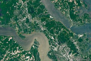
While Venezuela contains tropical jungles, famous waterfalls, and mountains, its northern tip stands out from the rest of the land. Connected to the mainland by a sliver of sand, the Paraguaná Peninsula is characterized by hot, dry conditions and beautiful beaches.
The peninsula was an island during the Pliocene (5.3 to 2.6 million years ago), but a sandy isthmus connected it to the rest of Venezuela within the past 12,000 years. Many pirates and smugglers sought refuge on the peninsula in colonial times. Today, the area is popular with tourists and oil companies. The peninsula is home to one of the largest crude oil refinery complexes in the world in the city of Punto Fijo.
Médanos De Coro National Park spans more than 90 square kilometers (35 square miles) of the isthmus. The park is popular for its massive sand dunes, or médanos, which are shaped by winds. Médanos De Coro is one of the few areas in South America with extensive dunes, some of which reach 40 meters (130 feet) tall.
The peninsula is one of the hotter regions of Venezuela, with an arid to semi-arid climate. The dry conditions are unusual for this latitude (between 10 and 12°N); most similar tropical areas typically abundant precipitation. Some researchers suggest trade winds constantly blowing along this coast dry out the land. Others say the dry weather is due to persistent high-pressure systems (associated with dry, sunny weather) and thermal differences between the sea and the land.
A sliver of green lines the highest points in the center of the peninsula: the Santa Ana Ridge rises up to 830 meters (2,700 feet) above sea level. Thorny plants live at lower elevations, while deciduous forests and woody plants grow at higher elevations. The area was designated the Cerro Santa Ana Natural Monument in 1972.
The image above was acquired on October 18, 2020, by the Operational Land Imager (OLI) on the Landsat 8 satellite.
References & Resources
- Encyclopedia Britannica Paraguaná Peninsula. Accessed April 8, 2021.
- Venezuela Tuya Paraguaná Peninsula. Accessed April 8, 2021.
- World Wildlife Fund Northern South America: Northernwestern Venezuela. Accessed April 8, 2021.
NASA Earth Observatory image by Lauren Dauphin, using Landsat data from the U.S. Geological Survey. Story by Kasha Patel.