


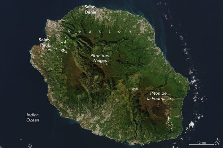
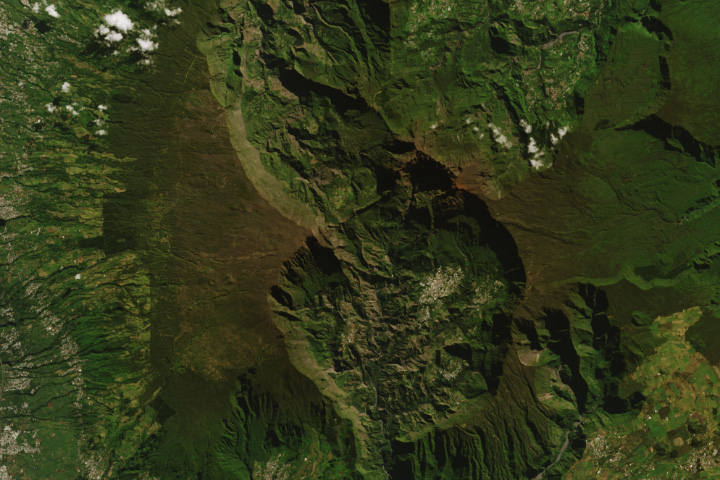
Piton des Neiges (Snow Peak) is an extinct shield volcano on Réunion Island and the tallest peak in the Indian Ocean. Despite its name, the peak is rarely snowy, but the surrounding landscape features lengthy hiking trails and a variety of rare plants and animals.
Located 700 kilometers (440 miles) east of Madagascar, Réunion Island likely originated from a tectonic hot spot on the ocean floor, emerging above the ocean surface about 2 million years ago. The island is dominated by two towering volcanoes: the dormant Piton des Neiges and the highly active Piton de la Fournaise. The two volcanoes can be seen in the image above, acquired by the OLI (Operational Land Imager) on Landsat 8 on May 23, 2022.
Piton des Neiges rises 3,069 meters (10,070 feet) above sea level. The volcano is heavily eroded with three large erosional cirques surrounding the central summit peak. The United Nations Educational, Scientific and Cultural Organization (UNESCO) describes these cirques as “massive natural amphitheatres with an imposing height and verticality.” The features offer starting points for hikes up to the island’s highest point. Due to the tropical climate of the island, snow almost never falls on Piton des Neiges. The name of the mountain, “Snow Peak,” is deserved only when a rare dusting falls on its summit during the “cold” season from late June to September.
The forested gorges, subtropical rainforests, and rugged terrain of the island harbor rare endemic species of plants, birds, and other wildlife. The Reunion Stonechat bird is one such endemic species. Locals refer to the small, round bird as a Tec-tec because of its call, frequently heard along the island’s trails. In 2010, the central part of Réunion Island was selected by UNESCO as a World Heritage cultural site for the beauty of its landscape and its exceptional biodiversity.
References & Resources
- Hawaiian Volcano Observatory (2001, March 29) Volcano Watch — Réunion island: sister island on the other side of the world. Accessed December 28, 2023.
- La Réunion The Piton des Neiges. Accessed December 28, 2023.
- NASA Earth Observatory (2001, January 31) Satellite Observations of Piton de la Fournaise, Réunion Island. Accessed December 28, 2023.
- United Nations Educational, Scientific and Cultural Organization (UNESCO) Pitons, cirques and ramparts of Réunion Island. Accessed December 28, 2023.
NASA Earth Observatory images by Wanmei Liang , using Landsat data from the U.S. Geological Survey . Story by Emily Cassidy .


