


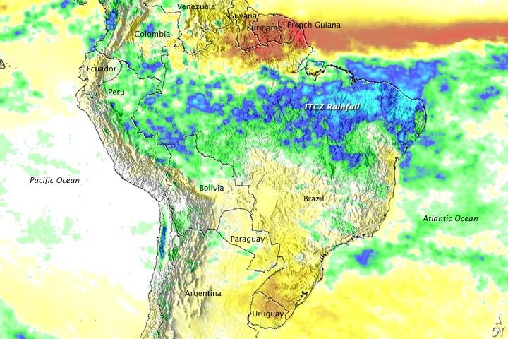
Heavy rain began to fall over northern Brazil in early April 2009 and persisted for several weeks, causing the most severe flooding in more than two decades. As of May 13, at least 39 people had died and over 300,000 had been displaced from their homes, reported the Associated Press. While northeastern Brazil is usually fairly dry, it does have a summer wet season that ramps up in February, peaks in April, and quickly falls off in May. This pattern is intimately tied to the seasonal migration of a band of showers and stormsthat wraps around the globe near the equator, the IntertropicalConvergence Zone (ITCZ). This band of rain showers shifts from north to south across the equator as the seasons change, bringing a cycle of rainy and dry periods to the tropics.
This image shows the unusually heavy rainfall the Intertropical Convergence Zone brought to northern Brazil in 2009. The image was based on data collected by the Tropical Rainfall Measuring Mission (TRMM) satellite between April 12 and May 12, 2009, compared to average rainfall (millimeters per day) observed during that period between 1998 and 2008. Areas in which rainfall was heavier than normal are blue, while drier-than-normal regions are brown. The most prominentfeature in the image is the large east-west band of very heavy rain stretching from theAtlantic Ocean in the East to the northern Andes mountains of Peru, Ecuador, andColumbia in the West. This band is a direct result of the ITCZ.
The ITCZ is a normal rainfall pattern, so what caused the unusual rain in 2009? The anomaly image provides a clue: immediately north of the heavy rain is a strong east-westband of below-normal rainfall, shown in brown. The overall anomaly pattern shows thatthe ITCZ remained locked over northeastern Brazil instead of migrating northward over French Guiana, Suriname, and Guyana as it would normally do.
One possible reason for this change in the ICTZ has to do with what is known as the North Atlantic Oscillation. The oscillation describes changes in the relative strengthsof two semi-permanent atmospheric pressure features over the North Atlantic: the IcelandicLow and the Azores High. When the index is positive, the pressure features arestronger. The NAO became strongly positive at the beginning of May, indicatingthat the Azores High was stronger than normal. As a result, stronger-than-normal trade winds from the northern hemisphere can flow in towards the ITCZin the southern hemisphere. These winds not only create a surge in moisture intothe ITCZ, but they can also impede its movement both directly and indirectly by blowingadditional warm ocean surface waters southward.
Using both a passive microwave sensor and a space-borne precipitation radar,TRMM measures rainfall from space. For increased coverage, TRMMcan be used to calibrate rainfall estimates from other additional satellites in an analysis called the TRMM-based, near-real time Multi-satellite Precipitation Analysis (TMPA). This image was made from TMPA rainfall totals for Brazil and the surrounding region. Additional images and a more detailed caption are available on the TRMM website. TRMM is a joint mission between NASA and the Japanese space agency, JAXA.
References & Resources
- Clandenning, A. (2009, May 13). Brazil floods ease, but 267K still homeless. Associated Press. Accessed May 15, 2009.
Image produced by Hal Pierce and caption by Steve Lang and Holli Riebeek.


