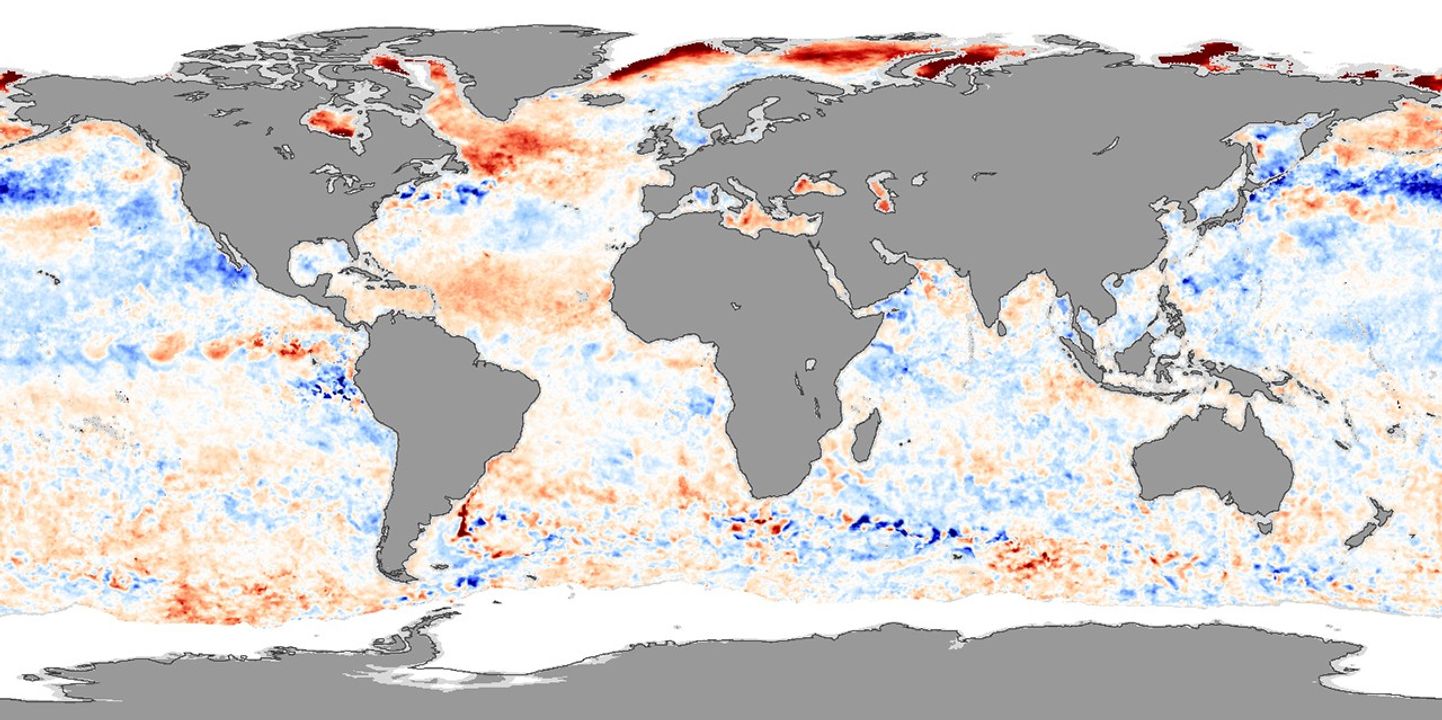

A band of abnormally warm water, shown in red, spans the Atlantic OceanfromAfrica to Central America in this sea surface temperature image fromAugust 5, 2005. The warmregion—Hurricane Alley—is the birthplace of hurricanes intheAtlantic, and unusually warm waters means that storms have plenty offuelto develop.
Hurricane Alley is heating up, and temperatures are warmer thanaverage(1985-1997). Not only does this mean that hurricanes may be more likelytoform, but the weather pattern that is causing the ocean to warm can alsosteer storms straight for Florida. The pattern may also be responsibleforthe July 2005 heat wave that swept across the Midwestern UnitedStates.
Normally, a large area of high atmospheric pressure sits firmlyentrenched over the Atlantic Ocean. Called the Bermuda or Azores Highbecause the center of the high pressure system shifts back and forthbetween the two islands, the system stirs air around the North Atlanticin a giant clockwise circle. A high-pressure system pushes air downtoward the surface, causing it to warm and dry out. In the warmer, drierair, fewer clouds form to shield the ocean from the sun, allowing watertemperatures to rise.
In the summer of 2005, the Bermuda High has been extended to thesouth and west, letting Hurricane Alley bake under relatively clearskies. The result is the streak of warm water seen in this image. Sinceone of the ingredients necessary for a hurricane to develop is warmocean water (at least 28 degrees Celsius or 82 degrees Fahrenheit), thisstreak could lead to more hurricanes during the 2005 season. On August2, the NationalOceanicand Atmospheric Administration (NOAA) increased their predictionsforthe 2005 season, warning that 11-14 storms may form between August andNovember in addition to the 9 that have already pushed through theAtlantic.
The south- and westward extension of the Bermuda High affects morethan sea surface temperatures. Remember, the Bermuda-Azores High spinsthe air over the Atlantic in a giant, clockwise circle. As hurricanesdevelop in Hurricane Alley, along the bottom side of the#8220;clock,” they travel west around the edge of the highpressure system. Often, the clockwise circulation pattern will bendstorms northward intothe Atlantic before they make landfall on the East Coast. But with theedges of the high pressure system extending farther south and west thannormal, storms can run into the United States as they make theirnorthward turn around the high-pressure system. In 2004, with theBermuda High in a similar position, a record four hurricanes poundedFlorida in rapid succession.
The weather pattern could also be connected to the high temperaturesacross the Midwestern United States. Just as the Bermuda High can sweephurricanes from the Atlantic into the United States, it also drags warmtropical air northward. Because the edge of the high sits farther westthan normal (closer to the U.S. East Coast), hot humid air iscirculating farther inland, leaving the Midwest hot and sticky.
This image was created from data gathered by the Advanced MicrowaveScanning Radiometer-EOS (AMSR-E) on NASA’s Aqua satellite onAugust5, 2005. AMSR-E was provided to the Aqua program by the JapaneseAerospaceExploration Agency (JAXA).
References & Resources
Sea Surface Temperature data from the Advanced Microwave Radiometer for EOS (AMSR-E), courtesy Remote Sensing Systems