
Winter conditions in the Arctic and Antarctic lead to the formation of sea ice. But in some places where sea ice should occur, open water appears instead. Persistent areas of open water amidst sea ice are known as polynyas. Often the result of the upwelling of warm ocean water, polynyas can also result from winds.
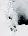
The Moderate Resolution Imaging Spectroradiometer (MODIS) on NASA’s Aqua satellite captured this natural-color image of a polynya off the coast of Antarctica, near Ross Island and McMurdo Station on November 16, 2011. The polynya was likely caused by katabatic winds, which derive their name from the Greek term for “descent.” The winds blow off Antarctica’s high interior toward the ocean and can attain hurricane strength—up to 200 miles (320 kilometers) per hour.
Strong winds have pushed sea ice away from the coast in this image, but not uniformly. Ross Island and the mountains to the west block some winds, so sea ice lingers near those landforms. Along the lower-elevation area east of Ross Island, winds clear the ice from a large stretch of ocean. North of the polynya, sea ice shows varying degrees of thickness, perhaps the result of alternating windy and calm spells.
Polynyas, ice shelves, and sea ice were prime targets for IceBridge, a NASA mission that uses airplanes equipped with radar and lidar to develop a three-dimensional view of Antarctic ice. The 2011 Antarctic campaign concluded on November 20. You can learn more about the mission in IceBridge: Building a record of Earth’s changing ice, one flight at a time.
References & Resources
- All about Sea Ice. Polynyas. National Snow and Ice Data Center. Accessed November 21, 2011.
- Antarctica: The End of the Earth. Unequaled extremes. PBS Nature. Accessed November 21, 2011.
NASA image courtesy Jeff Schmaltz, LANCE/EOSDIS MODIS Rapid Response Team at NASA GSFC. Caption by Michon Scott, based on image interpretation by Walt Meier and Ted Scambos, National Snow and Ice Data Center.