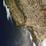
This natural-color image of a wildfire in southern California was acquired by the Moderate Resolution Imaging Spectroradiometer (MODIS) on NASA’s Terra satellite on July 23, 2016. Red outlines indicate hot spots detected by MODIS that are indicative of wildfire.
The fire consumed mountain chapparal and brush in Sand Canyon and Placerita Canyon, on the north edge of Angeles National Forest. According to InciWeb, the fire started on July 22. As of July 25, it had burned 33,117 acres (more than 51 square miles) and was 10 percent contained by more than 2,900 firefighters from Los Angeles County and the U.S. Forest Service.
Thousands of local residents have been advised to evacuate more than 10,000 homes. At least 18 structures and buildings have been destroyed. High temperatures and shifting winds, coupled with long-term drought, have fueled the blaze.
References & Resources
NASA Earth Observatory image by Jesse Allen, using data from the Land Atmosphere Near real-time Capability for EOS (LANCE). Caption by Mike Carlowicz.