
October 8, 2016
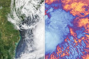
At 2:20 p.m. local time (18:20 Universal Time) on October 8, 2016, the Moderate Resolution Imaging Spectroradiometer (MODIS) on NASA’s Aqua satellite acquired this natural-color image of Hurricane Matthew as the storm churned along the coast of South Carolina.
More NASA Coverage of Matthew
- NASA Earth Observatory (2016, October) Matthew.
- NASA Goddard Space Flight Center (2016, October 8, ) Matthew (Atlantic Ocean) Accessed October 8, 2016.
- NASA Precipitation Measurement Mission (2016, October 7) Video: A Look Inside Matthew. Accessed October 8, 2016.
- Hazards Data Distribution System Explorer (2016, October 8) Hurricane Matthew. Accessed October 8, 2016.
References & Resources
- National Hurricane Center (2016, October 8) Hurricane Matthew. Accessed October 8, 2016.
NASA Earth Observatory image by Jesse Allen, using data from the Land Atmosphere Near real-time Capability for EOS (LANCE). Caption by Adam Voiland.