![Request for Information – Potential [Placeholder for Prize]](https://assets.science.nasa.gov/dynamicimage/assets/science/psd/solar/2023/09/s/solarsystem_0.jpg?w=1024)


January 17, 2015
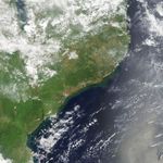
Flooding in Mozambique
Residents of Mozambique’s Zambezia province are accustomed to picking up their belongs and heading for higher ground during the wet season. But even by local standards, the onslaught in January 2015 has been unusual.
Weeks of heavy rainfall in December 2014 and January 2015 caused rivers in the province to swell. When a particularly strong tropical disturbance passed over Mozambique on January 14, 2015, the Licungo River, as well as other rivers in the region, began to flood. By January 20, the Licungo was higher than it had been since 1971. As of January 22, news media reported that floodwater had killed 86 Mozambicans, destroyed 11,000 homes, and displaced tens of thousands of people.
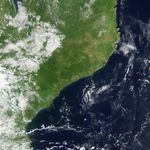
On January 17, 2015, the Moderate Resolution Imaging Spectroradiometer (MODIS) on NASA’s Terra satellite captured the top image, which shows flooding along the Licungo and other rivers in coastal Mozambique. Thick plumes of sediment-rich water are also visible in the Mozambique Channel. Though individual villages are not visible at MODIS’s spatial resolution, floodwaters have inundated dozens of villages. The lower image shows the same area on February 1, 2014.
When floods occur, satellites can do much more than provide natural-color imagery. For instance, researchers from the University of Colorado, NASA’s Jet Propulsion Laboratory, and NASA’s Goddard Space Flight Center publish near-real time maps of flooded areas as part of a project called the Flood Observatory. The scientists use data collected by MODIS, Landsat 8, and the European Space Agency’s Sentinel 1 to create the maps. For select locations, the researchers can also estimate river discharge based on data from microwave sounders on satellites such as Aqua, GCOM-W and TRMM. To learn more, visit the Flood Observatory’s resource page for this event.
References & Resources
- allAfrica (2015, January 20) Current Conditions and Maximum Flood Extent, 2015 Flooding in Malawi and Southern Mozambique. Accessed January 22, 2015.
- Dartmouth Flood Observatory (2015, January 22) Mozambique: Licungo Dropping, but River Basin Still Flooded. Accessed January 22, 2015.
- ENCA (2015, January 21) IN PICTURES: Floods ravage Mozambique as thousands are cut off. Accessed January 22, 2015.
- Masters, J. via Weather Underground (2015, January 15) Floods Kill at Least 260 in Malawi, Mozambique, and Madagascar. Accessed January 22, 2015.
- Jacarandafm (2015, January 21) VIDEO: Mozambique Flood Disaster. Accessed January 22, 2015.
- ReliefWeb (2015, January 19) Flood Waters Over Zambezia Province, Mozambique (as of 19 Jan 2015). Accessed January 22, 2015.
- ReliefWeb (2015, January) Southern Africa: Floods – Jan 2015. Accessed January 22, 2015.
NASA images courtesy the MODIS Rapid Response Team at NASA GSFC. Caption by Adam Voiland.