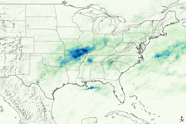
An early spring storm system advanced out of the Southern Plains in mid-March 2008, causing widespread flooding. Strong southerly winds developed ahead of an area of low pressure located over the Southern High Plains and drew moisture up from the Gulf of Mexico across Texas and Louisiana. This warm, moist air collided with a frontal boundary (the boundary between two air masses of different temperature, pressure, or humidity) that draped across central Texas into central Missouri. The convergence produced repeated bouts of thunderstorms and heavy rain from central Texas through Oklahoma and into Kansas and Missouri.
This image shows rainfall totals for March 13-20, 2008, based on output from the near-real-time, Multi-satellite Precipitation Analysis (MPA) at NASA Goddard Space Flight Center. The analysis is based in part on data from the Tropical Rainfall Measuring Mission (TRMM) satellite. Rain extends from central Texas northeastward up into southern Pennsylvania. The highest rainfall totals (shown in red) are about 200 millimeters (about 8 inches) and are located over western Arkansas. A broad area of rainfall of at least 100 mm (about 4 inches, shown in yellow) covers most of southern Missouri, northwestern Arkansas, and eastern Oklahoma, with embedded higher amounts on the order 150 mm (about 6 inches, shown in orange). TRMM does not observe rainfall with the same level of detail as ground-based rain gauges or weather radars; instead it sees a broad area at one time. Locally, there were reports of up to a foot of rain in parts of Missouri. At least 13 deaths were being blamed on the weather, and numerous rivers were at or above flood stage across the Midwest.
The ongoing La Niña (cooler-than-normal ocean temperatures across the central Pacific) may have contributed to the intense rain event. La Niña and its more famous counterpart, El Niño, can impact U.S. weather by altering the patterns of the jet stream, especially in the Northern Hemisphere cold season. On average for this time of year, strong to moderate La Niña events are linked to above-normal rainfall from East Texas and northern Louisiana up through Arkansas and the Tennessee and Ohio Valleys.
Since 1997, TRMM has been measuring rainfall over the global tropics using a combination of passive microwave and active radar sensors. Scientists can use TRMM data to calibrate rainfall estimates from other satellites. TRMM is a joint mission of NASA and the Japanese Space Agency, JAXA.
References & Resources
NASA images by Jesse Allen, using data provided courtesy of the TRMM team. Caption by Steve Lang (SSAI/NASA GSFC).