November 17, 2015
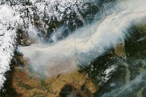
On November 17, 2015, the Visible Infrared Imaging Radiometer Suite (VIIRS) on Suomi NPP captured this image of smoke streaming from bush fires northwest of Esperance, Western Australia. The state’s Department of Fire and Emergency Services reported that the fires had burned 133,000 hectares (513 square miles) of land, damaged power lines, and destroyed two homes.
References & Resources
- Department of Fire and Emergency Services (2015, November 20) Bushfire ADVICE for Grass Patch, Salmon Gums and surrounding areas in the Shire of Esperance. Accessed November 20, 2015.
NASA Earth Observatory image by Jesse Allen, using VIIRS data from the Suomi National Polar-orbiting Partnership. Suomi NPP is the result of a partnership between NASA, the National Oceanic and Atmospheric Administration, and the Department of Defense. Caption by Adam Voiland.