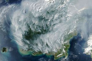




























From September into November 2006, fires burned over a broad area of southern Borneo and Sumatra. Thick haze hung over the region and spread across the region. This image of the islands was captured by the Moderate Resolution Imaging Spectroradiometer (MODIS)on NASA’s Aqua satellite on November 2, 2006. Places where MODIS detected actively burning fires are marked in red. It is possible that additional fires are burning on Borneo but that the thick smoke is preventing the sensor from detecting them. The fires will likely continue to burn until the monsoon rains get fully underway. A previous post for this event provides additional detail on the causes of fires on Borneo and Sumatra.
You can also download a 250-meter-resolution KMZ file of Borneo for use with Google Earth.
References & Resources
NASA image created by Jesse Allen, Earth Observatory, using data provided courtesy of MODIS Rapid Respose team.