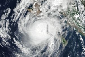





























Hurricane Emily is shown here in the Carribbean north of Venezuela on July 14, 2005. The image was captured by the Moderate Resolution Imaging Spectroradiometer (MODIS) on the Aqua satellite at 17:20 UTC (13:20 Eastern Daylight Time). At this time, it was a well developed and powerful hurricane with winds over 150 kilometers an hour (85 knots). It passed through the chain of islands known as the Windward Islands, causing one death in the city of St. George’s on Grenada. It is building up towards a Category 4 hurricane, the second strongest storm on the Saffir-Simpson intensity scale. Projections take it glancing off Jamaica, striking the Yucatan Peninsula in Mexico, and continuing across into the Gulf of Mexico to make landfall again somewhere near Brownsville, Texas on the border with Mexico and the United States.
Predicting hurricane strength and intensity is challenging, and Emily might be either stronger or weaker than expected, and it may not stay on its predicted course. The hurricane has already become somewhat stronger than first anticipated.
References & Resources
NASA image created by Jesse Allen, Earth Observatory, using data obtained from the MODIS Rapid Response team.