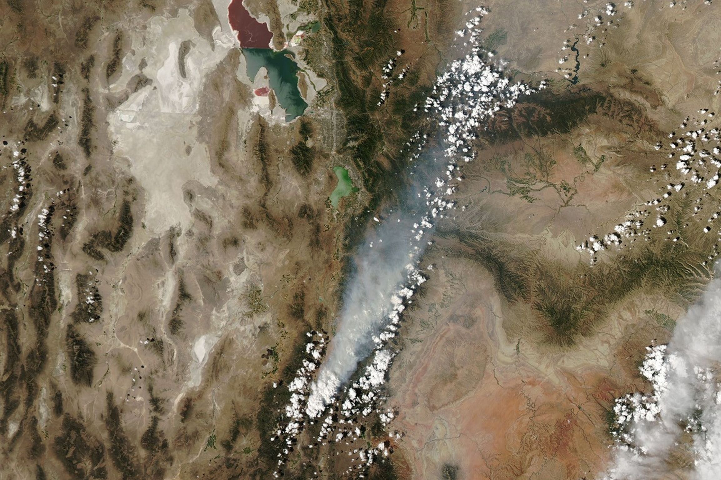

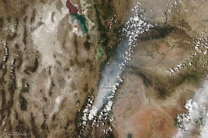
The Monroe Canyon fire in central Utah grew quickly in late July 2025 amid a stretch of hot, dry, and windy weather. The blaze, burning near the communities of Richfield, Monroe, and Koosharem, began its rapid expansion the afternoon of July 25, when firefighters reported wind gusts exceeding 60 miles (97 kilometers) per hour. Its extent would more than double to 23,265 acres (9,415 hectares) by the morning of July 28.
The fire continued to rage that day, when the MODIS (Moderate Resolution Imaging Spectroradiometer) on NASA’s Aqua satellite captured this image. A smoke plume from the blaze drifted hundreds of miles to the northeast, creating hazy skies and degrading air quality in areas downwind.
Fire activity prompted officials to close a portion of Fishlake National Forest and issue evacuation notices for residences within that area. Several buildings have been destroyed, according to news reports, and firefighters were working to prevent additional structures from being lost. About 1,000 personnel were involved in the firefighting response.
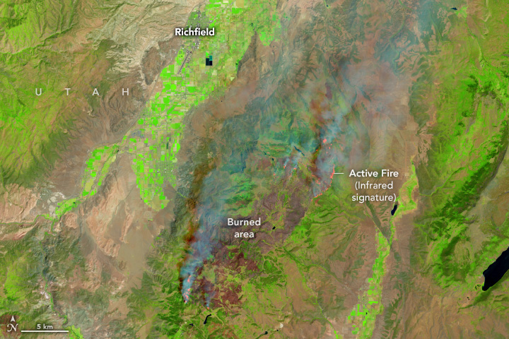
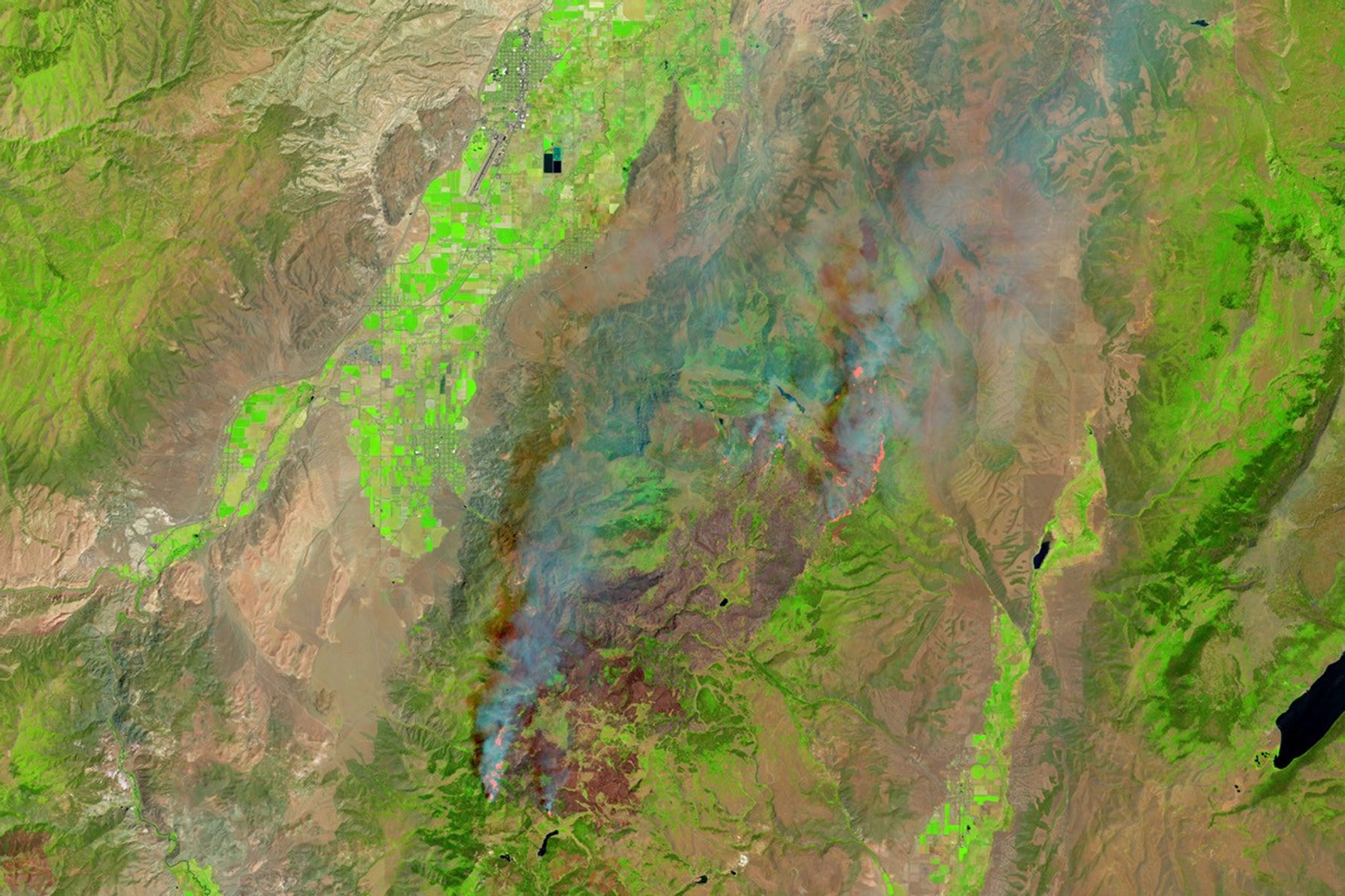
The OLI (Operational Land Imager) on Landsat 8 captured the false-color image above, showing the Monroe Canyon fire on July 28. This combination of shortwave infrared, near infrared, and visible light (bands 6-5-3) makes it easier to identify unburned, vegetated areas (green) and the recently burned landscape (brown). Bright orange indicates the infrared signature of active burning.
Over the past decade, the USDA Forest Service has used prescribed burns and mechanical thinning in and around Monroe Canyon to promote aspen regeneration and reduce accumulated brush and dead vegetation. NASA’s FireSense project collected airborne data before, during, and after one such prescribed burn in the area in October 2023, toward its goal of improving science resources delivered to operational fire agencies.
According to Utah’s Department of Natural Resources, the intensity of the Monroe Canyon fire decreased near the edge of these treatment areas. This helped firefighters add more blackline around the southeastern perimeter of the fire and increase containment on that side.
By the morning of July 31, the fire had grown to 45,964 acres (18,600 hectares) with 11 percent containment. In addition to the fire-conducive weather, officials stated that “record-breaking low fuel moistures” contributed to the intense fire activity. A red flag warning was in effect for central and southern Utah, with low relative humidity and breezy conditions expected to continue.
References & Resources
- ABC4 (2025, July 30) Red Flag Warnings in effect due to fire danger with high heat. Accessed July 30, 2025.
- InciWeb (2025, July 30) Monroe Canyon Fire. Accessed July 31, 2025.
- KSL (2025, July 28) Firefighters focus on protecting structures after Monroe Canyon Fire doubles in size. Accessed July 30, 2025.
- NASA Earth Observatory (2023, December 14) Making Fire Sense on Monroe Mountain. Accessed July 31, 2025.
- USDA Forest Service Monroe Mountain Aspen Ecosystems Restoration Project. Accessed July 31, 2025.
NASA Earth Observatory images by Wanmei Liang , using Landsat data from the U.S. Geological Survey and MODIS data from NASA EOSDIS LANCE and GIBS/Worldview . Story by Lindsey Doermann .