.png?w=1024)


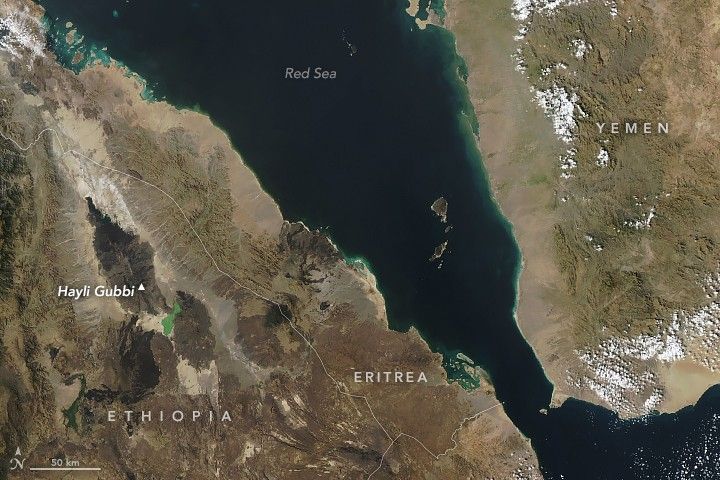
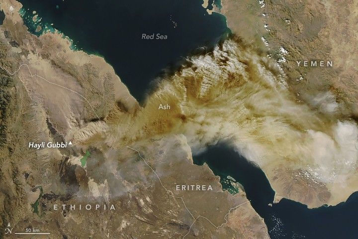


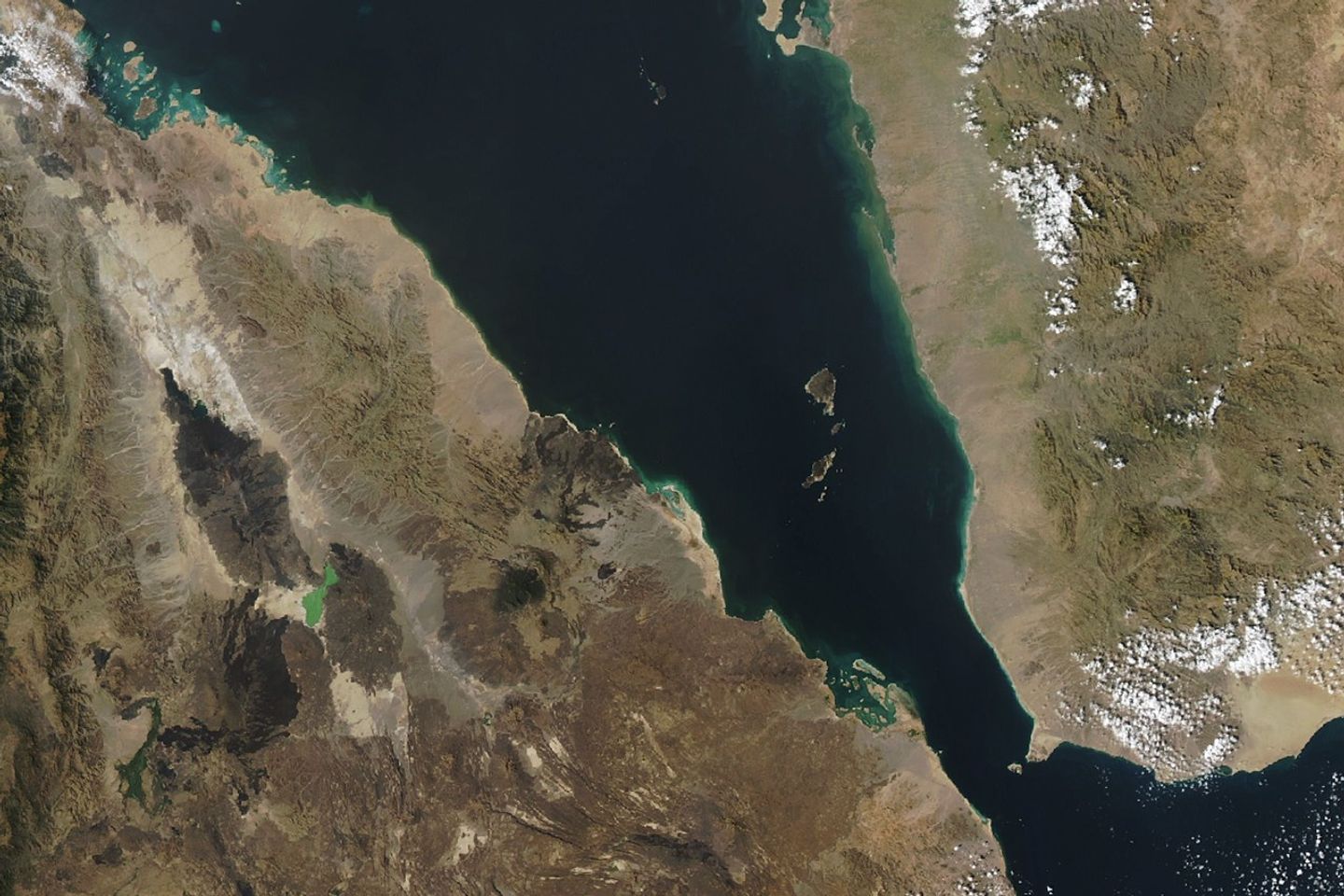
On November 23, 2025, the Hayli Gubbi volcano in northern Ethiopia erupted in dramatic fashion. The shield volcano in the Danakil (or Afar) Depression began spewing ash and volcanic gases at around 11:30 a.m. local time (8:30 Universal Time) that day, marking its first documented explosive eruption. The plume reached into the upper troposphere and drifted northeast, eventually crossing over northern India and China and disrupting flights.
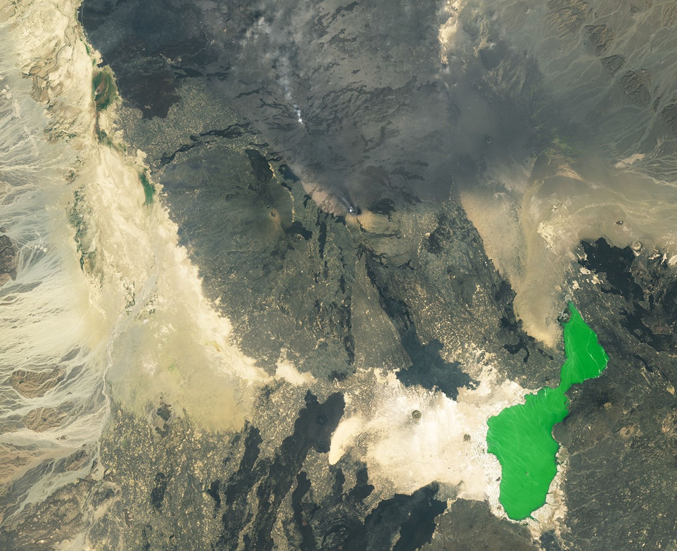
The MODIS (Moderate Resolution Imaging Spectroradiometer) instrument on NASA’s Aqua satellite acquired the image above (right) of the eruption, about 4 hours after it was first detected. Other satellite data indicated the plume reached 15 kilometers (9 miles) above sea level and contained approximately 0.2 teragrams (220,000 tons) of sulfur dioxide, according to a Global Volcanism Program report. Another light-colored cloud, likely of pyroclastic material, is visible spreading to the north and appears to be on or close to the ground, the report stated. For comparison, the left image was acquired with the same sensor on November 15, before the eruption.
In this remote area of East Africa, tectonic plates are moving away from each other, which allows magma to rise to the surface and feed several active volcanoes. Due in part to Hayli Gubbi’s remote setting, geologists are unsure when Hayli Gubbi last erupted. Geologic evidence suggests it was within the past 8,000 years, though experts speculate it may have been within the past few centuries.
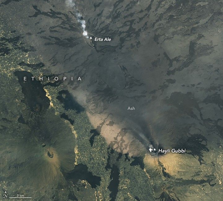
Hayli Gubbi lies about 12 kilometers (7 miles) south-southeast of Ethiopia’s most active volcano, Erta Ale, where a lava lake has roiled for decades. After Erta Ale’s most recent eruption in July 2025, scientists tracked the movement of magma beneath the surface using interferometric synthetic aperture radar (InSAR) measurements and other techniques. They found that magma propagated south from Erta Ale, passing beneath Hayli Gubbi and beyond.
Low-level activity was observed at Hayli Gubbi beginning in late July and included sulfur dioxide emissions, lingering white clouds in its summit crater, and upward ground displacement measuring several centimeters, according to the Centre for Observation and Modelling of Earthquakes, Volcanoes and Tectonics (COMET). The magma intrusion following Erta Ale’s eruption likely triggered the activity, said COMET co-director Juliet Biggs in a recorded statement.
Hayli Gubbi’s eruption was brief, subsiding by November 25, but caused visible changes to the land surface. Ash covered large areas, which included nearby villages in Ethiopia’s Afar region. Residents struggled with respiratory issues due to the ash fallout, and grass and water for livestock were contaminated, according to news reports.
The summit area of the volcano also took on a new appearance. The detailed view above, acquired with the OLI-2 (Operational Land Imager-2) on Landsat 9, shows the craters atop Hayli Gubbi and neighboring Erta Ale on November 24, 2025. The eruption enlarged Hayli Gubbi's existing crater, which is partially filled with a low-lying cloud in the image, and created two new craters to the southeast. Ash deposits cover older lava flows on the volcano’s slopes.
NASA Earth Observatory images by Michala Garrison, using MODIS data from NASA EOSDIS LANCE and GIBS/Worldview, and Landsat data from the U.S. Geological Survey. Story by Lindsey Doermann.
References & Resources
- AP News (2025, November 25) Eruption of long-dormant Ethiopian volcano subsides. Accessed December 3, 2025.
- Centre for Observation and Modelling of Earthquakes, Volcanoes and Tectonics (2025) Event Response Reports. Accessed December 3, 2025.
- Copernicus (2025, November 28) The new morphology of the Hayli Gubbi volcano. Accessed December 3, 2025.
- Global Volcanism Program (2025) Hayli Gubbi. Accessed December 3, 2025.
- La Rosa, A., et al. (2025) Segmented dike intrusion linked to multi-level magma storage during and before the 2025 eruption at Erta Ale (East Africa). Frontiers in Earth Science, 13:1719687.
- NASA Earth Observatory (2023, December 3) The Smoking Mountain. Accessed December 3, 2025.
- Simon Carn, via Bluesky (2025, November 23) An explosive eruption of Hayli Gubbi volcano. Accessed December 3, 2025.