


![Request for Information – Potential [Placeholder for Prize]](https://assets.science.nasa.gov/dynamicimage/assets/science/psd/solar/2023/09/s/solarsystem_0.jpg?w=1024)


Mars Global Surveyor Stories
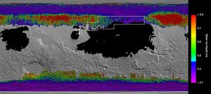
This rainbow-colored map shows underground water ice on Mars.
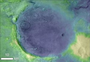
Lighter colors represent higher elevation in this image of Jezero Crater on Mars, the landing site for NASA's Mars 2020 mission. The oval indicates the landing ellipse, where the rover will be touching down on Mars.

The Delta II Program Team from NASA’s Launch Services Program (LSP) and United Launch Alliance (ULA) received The Nelson P. Jackson Aerospace Award for 2019 from the National Space Club and Foundation. Tim Dunn, NASA launch director, and Tory Bruno,…
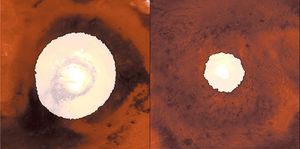
This image shows a side-by-side comparison from from NASA two infrared instruments of CO2 ice at the north (left) and south (right) Martian poles over the course of a typical year (two Earth years).
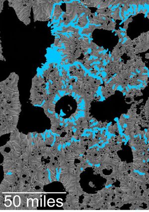
This map of an area within the Arabia Terra region on Mars shows where hydrologic modeling predicts locations of depressions that would have been lakes (black), overlaid with a map of the preserved valleys (blue lines) that would have been…
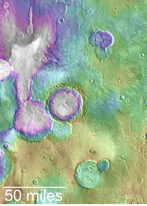
Valleys much younger than well-known ancient valley networks on Mars are evident near the informally named 'Heart Lake' on Mars. This map based on NASA's MGS data presents color-coded topographical information overlaid onto a photo mosaic.
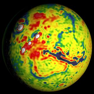
This map shows local variations in Mars' gravitational pull on orbiters, presenting unprecedented detail based on several years of data from tracking three of NASA's Mars orbiters.
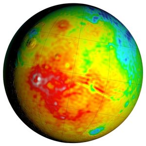
This Mars map shows variations in thickness of the planet's crust, the relatively thin surface layer over the interior mantle of the planet. It shows unprecedented detail derived from new mapping of variations in Mars' gravitational pull on orbiters.
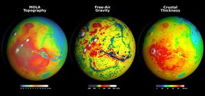
Newly detailed mapping of local variations in Mars' gravitational pull on orbiters (center), combined with topographical mapping of the planet's mountains and valleys (left) yields the best-yet mapping of Mars' crustal thickness (right).
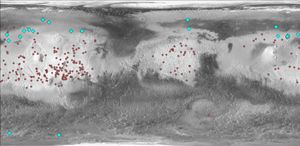
This map of Mars indicates locations of new craters that have excavated ice (blue) and those that have not (red). Albedo information comes from NASA's Mars Odyssey orbiter, and the map comes from NASA's Mars Global Surveyor orbiter.