Water Resources
From monitoring agricultural water use to identifying reservoir pollution, Landsat-based decisions impact millions of people’s access to this essential resource.
Landsat’s Role in Managing Water Resources
Water is essential for life. A quarter of Earth’s populace has unreliable access to clean water. With current population growth and environmental trends, the U.N. Environmental Program estimates that 1.8 billion people will face water scarcity by 2025. Water means survival for people and other species we rely upon to thrive, making proper stewardship of our water resources vital. Good decisions require good data. Since 1972 the Landsat series of satellites has been providing such data. Landsatbased decisions on how to manage limited water resources have impacted millions of people worldwide. From finding water for refugees in arid nations to reducing pollution in our national waterways, Landsat enables decisions that directly help people.

Landsat and Water Management PDF
Landsat Data for Local and Global Decision-making
- Locating water resources
- Assessing water pollution
- Managing watersheds
- Allocating water resources
Locating Water Resources
Access to fresh water is essential for survival. Landsat data support a water-finding tool for arid and semi-arid regions. The U.N. used this tool to find underground water sources for 200,000 Sudanese refugees in Chad in 2005. In 2011, the tool helped the U.N. to decide correctly where to drill for water in war-torn Darfur and Iraq. Because of Landsat’s suitable scale and spatial coverage, Landsat imagery has been used to create base maps of remote regions struggling with drought conditions. These maps serve as essential tools for humanitarian efforts.
Assessing Water Pollution
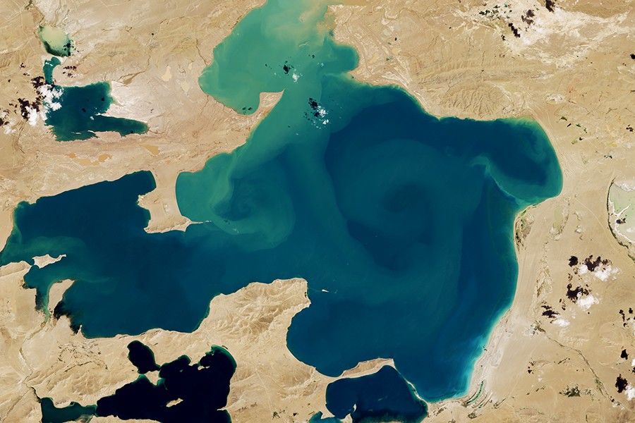
We rely on clean lakes, waterways, and reservoirs for safe swimming, fishing, and drinking water. Landsat provides valuable information about water conditions of inland and coastal water bodies. Using information from Landsat’s blue and red bands, the Minnesota Pollution Control Agency has been able to monitor Minnesota lake clarity—which is a key indicator for water quality—providing information on water quality for thousands of lakes that would be otherwise too costly to obtain. State resource managers use this information to watch for water quality changes and to target remediation efforts.

Managing Watersheds
The water in our lakes, bays, and estuaries comes from surrounding watersheds. Landsat data helps environmental managers limit the pollution—often excess nitrogen and phosphorus—that runs from watersheds to waterways. “Landsat is a critical and invaluable tool for characterizing the landscape and mapping it over time,” says Peter Claggett, a research geographer with the U.S. Geological Survey who monitors land use and water pollution in the massive Chesapeake Bay watershed that encompasses portions of six states. “Without the baseline set of information from Landsat we wouldn’t be able to really understand how sources of nutrients and sediment have changed and where they are in the Chesapeake Bay.”
Allocating Water Resources
Irrigation accounts for over 40 percent of fresh water withdrawals in the U.S. Increased demand for scarce water supplies has shifted water management strategies from increasing water supply to innovatively managing water use at sustainable levels. Landsat data is regularly used to quantify water consumed by irrigation. Landsat also serves as an impartial arbitrator in water right disputes. In the western U.S. where historical water use precedent is key to water right negotiations, the retrospective looks made possible by Landsat’s rich archive, appropriate spatial resolution, and thermal information (available since 1982) have made Landsat indispensable for U.S. western water resource managers. As Tony Morse, a retired geospatial technology manager from the Idaho Department of Water Resources explained, “we rely on publicly available, non-proprietary Landsat data. This means that the data for all parties to a conflict are consistently processed and equally available to all.”
Related Resources
- Combating drought in the Horn of Africa
- Mapping Chesapeakes’ Future from Today’s Land Use
- OpenET: A Satellite-Based Water Data Resource
Latest News

NASA satellites are helping Maine oyster farmers pick better sites and plan when oysters will be ready to harvest.
New research uses more than 40 years of data from NASA and the U.S. Geological Survey’s (USGS) Landsat satellites to…
Using data from Harmonized Landsat and Sentinel-2 (HLS), researchers developed a new algorithm to better monitor reservoir water levels in…