


Search Landsat
Filters
The Landsat 10 Spacecraft Request for Proposal (RFP) is available for review via SAM.gov as of Jul 14, 2026. Proposals are due Aug 13, 2026 at 1:00 PM EDT.
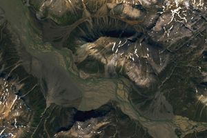
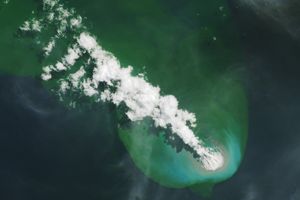
Sediment eroded from ice-capped mountains splays out across a broad river valley on Russia’s Severny Island.

Orange streams are now being spotted in hundreds of watersheds in permafrost areas throughout Alaska’s Brooks Range.

Marshy, sandy terrain and an impassable inlet helped colonial forces repel British forces during a pivotal battle on the barrier island near Charleston, South Carolina, on June 28, 1776.
Apollo astronauts previewed their roles as lunar field geologists in Alaska’s Valley of Ten Thousand Smokes.

Relentless rains are threatening a lake in Kenya's Great Rift Valley that has become a key hub in the global flower trade.

The Nebraska Sandhills—the largest system of sand dunes in the Western Hemisphere—stretch across about one-quarter of the state.
Buoyant volcanic rock fragments from an underwater eruption drifted across the Bismarck Sea and choked island coasts.

The city's metro area has pushed westward since it last hosted World Cup matches in 1986, expanding across a landscape shaped by ancient volcanoes.

Landsat’s Jim Irons won the prestigious William T. Pecora Award. Irons, now an emeritus scientist at NASA Goddard Space Flight Center, played an integral role in shaping the Landsat program into what it is today.