


FY 2004 Year in Review
Arctic Warming Affects Worldwide Climate: The Cold Facts About Warming Ice
A NASA study found that changes in Arctic temperatures and sea ice cover observed this year are remarkable compared to past years. The Arctic warming study appeared in the American Meteorological Society’s Journal of Climate showing that, compared to the 1980s, most of the Arctic warmed significantly over the last decade, with the biggest temperature increases occurring over North America. The conclusions show the Arctic changing in ways that were unobservable until the advent of satellite remote sensing. Satellite data are allowing researchers to see Arctic changes and develop an improved understanding of the effect on climate worldwide.
In addition to using data from passive satellites, as shown here, scientists are now able to use NASA’s ICESat satellite to understand how the Arctic region is changing. ICESat uses a laser technology called lidar to measure the thickness and extent of sea ice from space. These exciting new data are currently providing scientists with information they need to further understand changing ice extent and how it contributes to changes in sea level and ocean circulation, which can in turn affect climate and agriculture worldwide, habitats for sea life, and accessibility of Arctic shipping lanes.
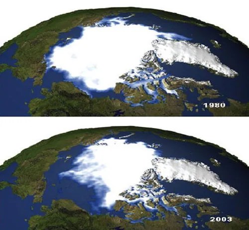
Photo: These images illustrate the magnitude of the difference in ice cover, which is about 1.6 million km2, between 1980 and 2003. The comparison shows a dramatic decrease in the Arctic’s ice cover. Scientists are currently using new technology in NASA’s ICESat satellite to measure both the thickness and extent of sea ice in the Arctic, and thereby gain a deeper understanding of the consequences of this change.
Satellites Used To Discover Chameleon Species New to Scienceear
NASA-supported biologists developed a modeling approach that uses satellite data and specimen locality data from museum collections to successfully predict the geographic distribution of 11 known chameleon species in Madagascar. The model also helped lead to the discovery of seven additional chameleon species new to science. The discovery shows that NASA satellite data and data from museum collections can help identify places to survey for new species of life, while locating areas likely to be of conservation importance. The study appeared in the December 2003 issue of the Nature journal and demonstrated that existing museum collections and satellite measurements of Earth’s surface and climate hold great promise for the accurate prediction of species distributions.
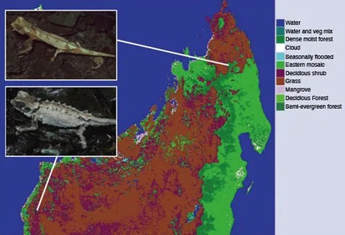
Satellite Image: Satellite-measured environmental variables such as land cover were used to predict the location of previously unknown chameleon species in Madagascar.
Black Soot and Snow:
A Warmer Combination
A new NASA study found that emissions of soot, or black carbon, alter the way sunlight reflects off snow. A computer simulation indicated that soot may be responsible for as much as 25 percent of observed global warming over the past century. Soot on snow absorbs more of the Sun’s energy and heat than icy, white backgrounds, which reflect the Sun’s rays. With global warming, many snow- and ice-covered areas are already melting. As can be seen when glaciers and ice sheets melt, they tend to get dirtier as the soot becomes even more concentrated. Soot thereby adds to the warming effect as ice melts, making icy surfaces darker and absorbing more solar energy. Soot is generated from traffic, industrial pollution, outdoor fires, and household burning of coal and other fuels, and is the product of incomplete combustion. The soot particles absorb sunlight very effectively, just as wearing a black shirt outdoors absorbs more solar energy and keeps you warmer than a white shirt.
Stardust Makes Historic Fly-by of a Comet
The new year 2004 started out on January 2 with a close flyby of a comet by NASA's Stardust mission, which was sent there to collect samples of the ancient object. Images and other data have revealed a much stranger world than previously believed. Stardust flew 236 kilometers (about 147 miles) from comet Wild 2. The flyby yielded the most detailed, high-resolution comet images ever, revealing a rigid surface dotted with towering pinnacles, plunging craters, steep cliffs, and dozens of jets spewing material into space. Launched in 1999, the Stardust spacecraft is headed back to Earth with its payload of thousands of captured particles. The spacecraft’s sample return capsule is scheduled to make a soft landing in the Utah desert in January 2006.
Mars Rover Is A Big Hit On Mars and Earth
Achieving a feat unparalleled in history, NASA successfully landed two mobile geology labs on the surface of Mars on January 3 and January 24. NASA 's Mars rovers Spirit and Opportunity drew tremendous worldwide interest in 2004 when they landed on the red planet respectively. Within weeks, Opportunity had discovered evidence that its landing site had been the location for a standing body of water sometime in the distant past, raising the possibility that the necessary ingredients for life may have existed on Mars at one time.
In April, both rovers successfully completed their primary three-month missions and went into bonus overtime work. During the summer, Spirit completed a three-kilometer (two-mile) trek southeast to the Columbia hills. Opportunity descended into Endurance Crater, where it found layer upon layer of rocks bearing evidence that they had once been drenched in water. Spirit and Opportunity were still in good health well past their intended operational lifespan, though beginning to show signs of aging. Public interest in the Rovers exploits were seen in front page headlines around the world, and made the NASA web portal the most visited web site in the world the week of the landings.
Satellites Record Weakening of the North Atlantic Current
NASA scientists have found that circulation in the northern North Atlantic Ocean weakened considerably in the late 1990s, based on the satellite record of this system. Slowing of this ocean current is an indication of dramatic changes in the North Atlantic Ocean climate. This subpolar system moves water in a counterclockwise pattern from Ireland to Labrador, carrying warm water to northern Europe, moderating that area’s climate. The satellite record is too short to determine whether this trend is part of a natural cycle or the result of factors related to global warming. Satellite data makes it possible to view the current over the entire North Atlantic basin. A new satellite in development at NASA called the Ocean Surface Topography Mission will use active satellite sensors to provide scientists with the expanded and improved information needed to quantify how Earth’s ocean circulation is changing and thereby gain insight into what the consequences might be for life on Earth.
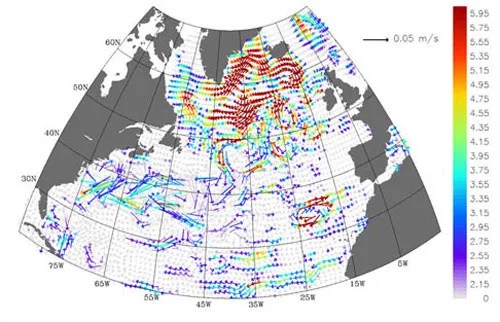
Image: This picture shows the slowing of the North Atlantic Ocean circulation system. The trend of the velocities (meters per second per decade) is going the opposite direction of the current, indicating slower speeds. These data are from May 1992 to June 2002 from the NASA Pathfinder altimeter. The colored vectors show the height, direction, and velocity of the current.
Cassini-Huygens Becomes First Mission To Orbit The Ring World Saturn
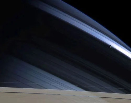
Photo: In a splendid portrait created by light and gravity, Saturn's lonely moon Mimas is seen against the cool, blue-streaked backdrop of Saturn's northern hemisphere. Delicate shadows cast by the rings arc gracefully across the planet, fading into darkness on Saturn's night side. The part of the atmosphere seen here appears darker and more bluish than the warm brown and gold hues seen in Cassini images of the southern hemisphere, due to preferential scattering of blue wavelengths by the cloud-free upper atmosphere.
After a seven-year, 2-billion mile (3.5-billion kilometer) journey, Cassini-Huygens became the first spacecraft ever to go into orbit around the ringed planet on July 1, 2004. The joint NASA, European Space Agency and Italian Space Agency Cassini-Huygens mission made a grand entry with a 96-minute engine burn and dramatic crossing of the rings. Dozens of stunning ring images showed hundreds of ringlets, waves and ripples. Cassini found that the planet is roiled by storms, detected lighting, discovered a new radiation belt, found four new moons and a new ring around Saturn, and for the first time has mapped the composition and temperature of the rings. On October 26, Cassini flew by the moon Titan at a distance of 745 miles (1,200 kilometers), the closest any spacecraft has ever come to the largest moon of Saturn. Titan is a prime target of the Cassini-Huygens mission because it is the only moon in our solar system with an atmosphere.
NASA's "Aura" Around Earth
NASA’s Aura satellite successfully launched into orbit on July 15, 2004, on a Delta II 7920 rocket from Vandenberg Air Force Base, CA. Aura uses cuttingearth science 2004 a year in review National Aeronautics and Space Administration edge new technologies to provide global-scale information about Earth’s atmospheric composition to understand and thereby provide the information needed to protect the very air we breathe. Aura will survey the atmosphere from the surface, where we live, through the upper atmosphere, where the ozone layer protects life on Earth. Aura’s observations will provide the information needed to understand how atmospheric composition affects and responds to Earth’s changing climate, to reveal the processes that connect local and global air quality, and to track the extent to which Earth’s protective ozone layer is recovering. Aura’s four instruments will survey different aspects of Earth’s atmosphere and will provide the most complete picture to date of the composition of our planet’s atmosphere. The Aura mission is a collaboration with the Netherlands, the United Kingdom, and Finland.
The Weight of Earth's Water from Space
Water covers approximately 70 percent of our world’s surface, yet only 0.5 percent of Earth’s water is available fresh water that can help meet the growing demands of society. Most of this fresh water resides in ground-water reservoirs that are hard to measure. In 2004, the Gravity Recovery And Climate Experiment (GRACE) science team reported that GRACE is demonstrating the first-ever capability to weigh Earth’s fresh water from space. The GRACE satellites measure changes in Earth’s gravitation field that signal shifts in the movement of water on Earth. GRACE consists of a pair of satellites that were launched in 2002. The mission was tasked with improving the gravity field by at least a factor of 10 and measuring monthly gravity fields. Last year, GRACE reported a global gravity field 50 to 100 times more accurate than previously available.
Genesis Crash Lands But Brings Home Precious Samples
On September 8, 2004, the Genesis solar sample return mission made a hard landing on the desert of Utah when its parachute failed to open. The return capsule suffered damage but even so managed to preserve a significant portion of the precious samples of the Sun it had brought back from space. The Genesis mission was launched in August 2001 on a journey to capture samples from the Sun. The Genesis scientists are encouraged they will be able to achieve the most important portions of their science objectives, which should tell us about the conditions that existed at the birth of the Sun and the planets over 5 billion years ago.
Hubble Sees Farther Than Ever Before Seen
Astronomers used NASA's Hubble Space Telescope to take the deepest portrait of the visible universe ever achieved by humankind. Called the Hubble Ultra Deep Field (HUDF), the million-second-long exposure reveals the first galaxies to emerge from the so-called "dark ages," the time shortly after the big bang when the first stars reheated the cold, dark universe. The new image should offer new insights into what types of objects reheated the universe long ago. The image reveals galaxies that are too faint to be seen by ground-based telescopes, or even in Hubble's previous faraway looks. One astronomer remarked, "Hubble takes us to within a stone's throw of the big bang itself."
Hubble Space Telescope Web Site
Spitzer Space Telescope Unveils Strange Cosmic Sights
The Spitzer Space Telescope, launched on August 24, 2003, pierced through cosmic dust to reveal hidden objects, including a family of newborn stars whose birth was triggered by the death of another star; a dying star surrounded by a mysterious donut-shaped ring; and a cannibalistic galaxy with a strange parallelogram-shaped meal at its core. The telescope also peered deep into the dustiest regions of space and spotted cold and dusty planet-forming discs, which are the "planetary construction zones" around stars. One of the discs was discovered to harbor what may be the youngest planet ever detected. Spitzer also identified one of the farthest galaxies ever seen, and was able to measure its age and mass for the first time. The Spitzer Space Telescope also joined forces this year with NASA's other Great Observatories -- the Hubble Space Telescope and Chandra X-ray Observatory -- to study a supernova and distant black holes.
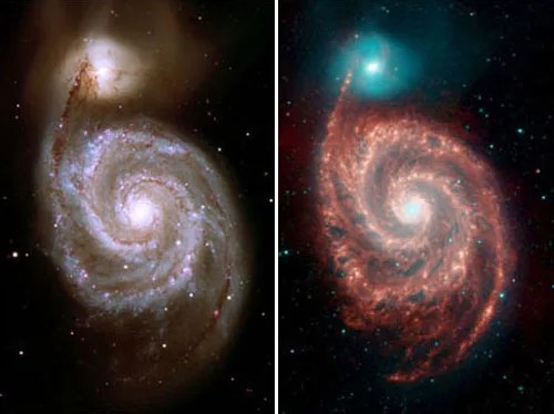
Photo: NASA's Spitzer Space Telescope has captured infrared images of the "Whirlpool Galaxy" (M51), revealing strange structures bridging the gaps between the dust-rich spiral arms, and tracing the dust, gas and stellar populations in both the bright spiral galaxy and its companion. The Spitzer image, right, is a four-color composite of invisible light, showing emissions from wavelengths 10 times longer than those seen by the human eye. The visible light image at left comes from the Kitt Peak National Observatory 2.1 meter telescope and is also a four-color composite. The Whirlpool Galaxy, 37 million light-years away, is a favorite target for amateur and professional astronomers alike. Photo Credit: NASA, JPL-Caltech, R. Kennicutt (University of Arizona)
NASA and EPA Air Quality Forecasts
NASA and the Environmental Protection Agency (EPA) are working together to improve air quality forecasts that are used to issue public air quality notifications. The two agencies are relating NASA satellite measurements of aerosol optical depth and cloud optical thickness with EPA ground measurements (AirNOW). NASA provided EPAwith a nearreal- time data-fusion product that served as a prototype during the pollution aerosol season in the fall of 2003. This prototype involved NASA aerosol and cloud data, NOAA wind speeds and fire locations, and EPA ground data. The prototype served air quality forecasters who used the 3-day visualizations of the data-fusion products to assess transport of aerosols into their region and then developed the air quality forecasts they issued to the public (e.g., severe air quality notifications).
Most Distant Object In Solar System Discovered

Artist's Conception: Standing on Sedna - the solar system's most distant known planetoid - your view of the Sun at high noon might look something like this. An artist's dramatic vision, the picture shows the Sun suspended above the nearby horizon as a bright star immersed in the dusty ecliptic plane. Within the dust-scattered sunlight are more familiar members of the solar system, including planet Earth. But at a distance of about 13 billion kilometers (8 billion miles) Earth would only be visible in binoculars or a small telescope. Illustration by Adolf Schaller
NASA-funded researchers have discovered the most distant object orbiting Earth's Sun. The object is a mysterious planet-like body three times farther from Earth than Pluto.
"The Sun appears so small from that distance that you could completely block it out with the head of a pin," said Dr. Mike Brown, California Institute of Technology, Pasadena, Calif., associate professor of planetary astronomy and leader of the research team. The object, called "Sedna" for the Inuit goddess of the ocean, is 13 billion kilometers (8 billion miles) away, in the farthest reaches of the solar system.
Earth System Scholars Fueling the S&T Workforce
Anticipating the challenges in understanding and predicting change in the highly complex Earth system, NASA has invested over a decade in preparing the next generation of Earth system scholars who are particularly equipped to advance our understanding of Earth using data from the unprecedented fleet of advanced Earth observing satellites. The scientists and engineers from NASA’s Earth System Science Fellowship Program (graduate) and the New Investigator Program (early career) now work in many sectors in the U.S. and abroad, including basic and applied research, policy, and industry. Many are leaders in their respective fields. Their desire to collaborate with each other and continue to contribute to NASA’s Mission to understand and protect our home planet has prompted them to form the Earth System Scholars Network. These highly motivated and scientifically sophisticated individuals, in turn, educate and inspire another generation of Earth system scholars. They are our science and technology workforce, fueling the Nation’s competitiveness, economy, and security.
Earth Science Technology Aids in Shuttle’s Return to Flight
An Earth Science-funded infrared-imaging technology was selected to detect flaws in the leading edges of the Shuttle wings. Originally created under the Earth Science Laser Risk Reduction Program as a way to diagnose problems in diode laser arrays for use in Earth observing satellites, this technology was adopted by the Leading Edge Infrared Camera Team to help inspect the Shuttle panels for tiny cracks, mechanical stresses, and other defects. The new infrared imaging capability will greatly increase NASA’s ability to discover irregularities by sensing heat absorbed by the panels and by measuring rates of cooling.


