


Mission
Hydrosphere improves the observation, understanding, and prediction of the distribution and movement of water in the Earth System. Specifically, NASA Hydrosphere studies water and energy cycles across land, ocean, and the atmosphere through the integration of measurements from satellites, surface networks, and airborne campaigns.
Hydrosphere News
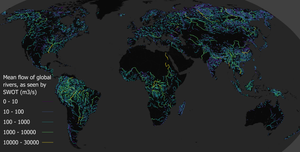
Science teams at NASA and the French space agency CNES (Centre National d’Études Spatiales) have released the first-ever global estimate…
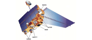
Launched into the night sky more than 26 years ago, on Dec. 18, 1999, from Vandenberg Air Force Base (now…
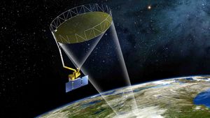
Introduction On November 16, 2025, the Sentinel-6B satellite launched from Vandenberg Space Force Base (VSFB) in California. The mission is…
Introduction The NASA Soil Moisture Active Passive (SMAP) mission, launched in 2015, has over 10 years of global L-band radiometry…

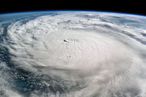
Data provided by the water satellite are helping to improve tsunami forecast models.
NASA's cutting-edge research, technology, and tools bolster the nation’s readiness and response to severe weather.
Overview
NASA Hydrosphere directs research and manages satellite and airborne missions that explore the variability, residence, and transport of oceanic, atmospheric, and terrestrial water. It supports intradisciplinary studies of the global water and energy cycle, sea-level rise and coastal impacts, air–sea interactions, and the integrated role of the hydrosphere–biosphere in the Earth system. We engage in collaborative efforts across NASA Earth Science and support a wide range of interagency and international initiatives to monitor, understand, and predict Earth’s water. The program also provides scientific support for major NASA satellite missions. Finally, NASA Hydrosphere engages in work that collaborates with other elements across the research Spheres, within NASA Earth Science (Earth Action, Data Systems, and Technology) and beyond (i.e., interagency and cross-agency efforts).
The Core Science That Drives NASA's Hydrosphere Research
-
Ocean Physics: Ocean heat and energy budget, ocean circulation, sea level and surface topography, salinity, ocean surface winds
-
Precipitation Science: Precipitation processes and variability, lightning science, planetary boundary layer impacts on clouds and convection
-
Terrestrial Hydrology: Water stores and fluxes such as soil moisture, snow, groundwater, streamflow, evapotranspiration, as well as feedbacks between land and atmospheric circulations at diurnal to seasonal timescales and meso- to synoptic spatial scales
-
Interdisciplinary Hydrosphere Science: Land-atmosphere-ocean interactions, local-regional-global water and energy budgets, water availability and circulation, satellite data assimilation
Funded Research Opportunities
Solicited program elements relevant to Hydrosphere are publicized through the Research Opportunities in Space and Earth Sciences (ROSES) NASA Research Announcements (NRAs) on the NASA Solicitation and Proposal Integrated Review and Evaluation System (NSPIRES) website. Past, open, and future solicitations can be searched and viewed on NSPIRES.
- A.2 Earth Venture: TROPICS and PREFIRE Science and Applications Teams: Step-1 due September 18, 2025, Step-2 due November 13, 2025
- A.3 NASA-ISRO Synthetic Aperture Radar (NISAR) Mission Research and Applications Science Team: Step-1 due March 13, 2026, Step-2 due May 14, 2026
- A.4 Rapid Response and Novel Research in Earth Science: No due date
- A.5 Earth Venture Suborbital-4 Snow4Flow Science Team: Due September 9, 2025
- F.5 Future Investigators in NASA Earth and Space Science and Technology: Due date TBD
Research Areas
-
Ocean Physics
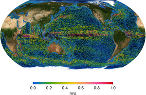
The ocean plays a fundamental role in the Earth’s system. It shapes our planet’s climate and weather by absorbing, storing, and transporting large quantities of heat, water, and moisture. Ocean Physics enables research that advances our understanding of the ocean’s role in the Earth’s system. Our scientists utilize NASA satellite and sub-orbital data, models, and data science to study ocean dynamics, sea level rise, hydrological cycle, and ocean interactions within the Earth system.
Ocean currents at multiple depths generated from the Estimating Climate and Circulation of the Ocean (ECCO) model. The ECCO model assimilates measurements from multiple NASA ocean observing satellite missions.NASA/Scientific Visualization Studio -
Precipitation Science
The NASA Precipitation Measurement Missions (PMM) Science Team conducts scientific research including algorithm development, mission implementation, product validation, and data utilization in support of the Global Precipitation Measurement (GPM) and Tropical Rainfall Measuring Mission (TRMM) satellites. Research topics include storm structure and mesoscale dynamics, the global water cycle, and precipitation microphysics. In addition, Precipitation Science supports novel work on lightning research. Instruments have been designed, constructed, and deployed by NASA as ground-based, airborne, and space-based sensors capable of detecting and characterizing lightning. Other non-exhaustive topics comprise refining the global thunderstorm and lightning climatology, determining relationships between the electrical characteristics of storms and precipitation, and refining lightning forecasts for applications such as better predicting lighting-induced wildfires and maturing lightning launch commit criteria in support private and public sector rocket launches.
 The ten satellites in the Global Precipitation Measurement (GPM) constellation provide unprecedented information about the rain and snow across the entire Earth.NASA/Scientific Visualization Studio
 -
Terrestrial Hydrology
NASA Terrestrial Hydrology (TH) is dedicated to advancing the nation's capability to observe, understand, and predict essential terrestrial water resources, including soil moisture, snow, groundwater, streamflow, and evapotranspiration, using NASA satellites and models. TH fosters a comprehensive understanding of the global water cycle's complex interactions by collaborating with other Earth Science Division research studying precipitation, cryospheric science, ecosystems, physical oceanography, and water resources management. TH balances the utilization of data from NASA’s current Earth-observing fleet with proactive preparation for future missions and the pursuit of innovative technologies crucial for enabling future scientific and societal benefits. Investments from TH also contribute to cultivating a skilled science and applications community proficient in using NASA satellite data and developing associated tools. TH addresses the following overarching questions: (1) How can we better observe, understand, and predict the distribution and movement of water on Earth from space? (2) How does human water resources management modify water and energy cycles locally, regionally, and globally, and what are the short- and long-term consequences of these changes to water security? (3) How important are land-atmosphere interactions relative to large scale atmosphere-ocean dynamics in hydrologic extremes prediction? and (4) How can we accurately and consistently estimate water availability across different scales of space and time, and what are the limitations of these methods?
 A depiction of the global land/ocean water cycle as represented by NASA's Modern Era Retrospective-analysis for Research and Applications version 2 (MERRA-2) with water volumes in units of 1000 cubic km per year. MERRA-2 assimilates more than 6 million observations every six hours and merges the available observations with a global numerical weather prediction model, which provides a quantification of the water cycle.NASA/Michael Bosilovich
Hydrosphere Data Access and Distributed Active Archive Centers (DAACs)
- Alaska Satellite Facility (ASF) DAAC
- EarthData DAACs
- Global Hydrology Resource Center
- Goddard Earth Sciences (GES) Data and Information Services Center (DISC)
- National Snow and Ice Data Center (NSIDC) Snow and Soil Moisture
- Physical Oceanography DAAC (PO.DAAC)
- Precipitation Processing System
Missions and Campaigns
-
Missions
NASA Earth Science missions see Earth from space and enable researchers to monitor and understand our home planet. Missions range from instruments onboard the International Space Station (ISS) to Earth-orbiting satellites that span both large and small (i.e., CubeSats) form factors. NASA’s Earth Science missions often have US or other international partnerships and frequently collect data for 10 or more years.
-
Campaigns
Campaigns use instrumented aircrafts, balloons, ships, and surface networks over land and ocean, to better observe and understand our home planet. Campaigns represent coordinated efforts with intensive observation periods over one or more regions that can last anywhere from weeks to years. These measurements help support missions by providing initial tests of instruments before they are launched to space. Campaigns also provide important measurements to calibrate and validate satellite data in addition to collecting observations in support of related scientific endeavors.

Public Events
Upcoming Meetings and Workshops
- Ocean Sciences Meeting 2026, 22-28 February 2026, Glasgow, Scotland
- Decadal Survey Planetary Boundary Layer Incubation Community Meeting, 12-13 May 2026, Pasadena, CA, USA
- Cloud Electrification Workshop, 8-11 June 2026, Merritt Island, FL, USA
- CYGNSS Science Team Meeting, 9-11 June 2026, Ann Arbor, MI, USA
Select Recent Meetings and Workshops
- INSPYRE 2026 Science Team Meeting, 18-20 February 2026, Iowa City, IA, USA
- 106th American Meteorological Society (AMS) Annual Meeting, 25-29 January 2026, Houston, TX, USA
- American Geophysical Union (AGU) 2025 Fall Meeting, 15-19 December 2025, New Orleans, LA, USA
- Sentinel-6B Workshop, 16 November 2025, Buellton, CA, USA
- INCUS Science Team Meeting, 4-7 November 2025, Fort Collins, CO, USA
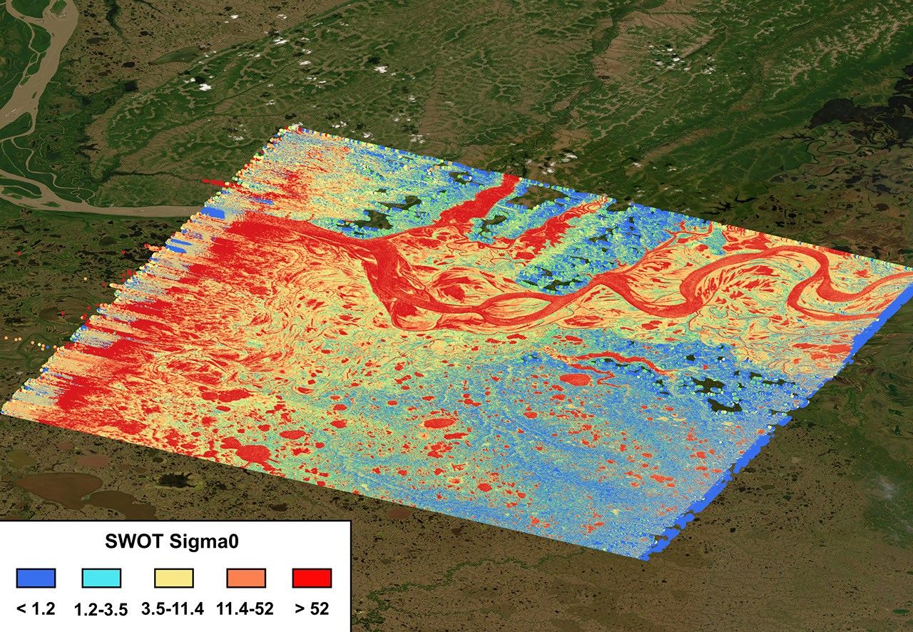
- SWOT Science Team Meeting, 14-17 October 2025, Arcachon, France
- Decadal Survey Planetary Boundary Layer Incubation Community Technical Meeting, 15-16 September 2025, Hyattsville, MD, USA
- NURTURE Science Team Meeting, 3-5 September 2025, Hampton, VA, USA
- Decadal Survey Planetary Boundary Layer Incubation Community Meeting, 1-3 April 2025, Silver Spring, MD, USA
Program Links, Science Teams, and Collaborations
Ocean Physics
- NASA Ocean Physics Page
- Salinity and Stratification at the Sea Ice Edge (SASSIE)
- Sea Level Change
- Sentinel-6 Science Team
- Sub-Mesoscale Ocean Dynamics Experiment (S-MODE)
- Surface Water and Ocean Topography (SWOT) Science Team
- Ocean Surface Salinity
- Ocean Vector Winds
Precipitation Science
- INvestigation of Convective UpdraftS (INCUS) Science Team
- Precipitation Measurement Missions Science Team
- Short-term Prediction Research and Transition Center
- U.S. Interagency Council for Advancing Meteorological Services (ICAMS)
Terrestrial Hydrology
- Global Energy and Water Exchanges (GEWEX) Program
- Land Information System
- NASA-ISRO Synthetic Aperture Radar (NISAR) Mission
- SnowEx
- Soil Moisture Active Passive (SMAP) Science Team
Other Interagency and International Partnerships
- Joint Center for Satellite Data Assimilation (JCSDA)
- Joint Program Planning Group (JPPG)
- National Oceanographic Partnership Program (NOPP)
- World Meteorological Organization
Contacts
Craig R. Ferguson
Hydrosphere and Enabling Capabilities Program Manager (dual role)
Terrestrial Hydrology Research and Integrated Earth System Modeling Program Scientist (Scientific Computing Manager)
Contact | Bio
Jessica Hausman
Hydrosphere Associate Program Scientist (ASRC Contractor)
Ocean Physics Research
Contact | Bio
Justin Stachnik
Atmosphere and Hydrosphere Associate Program Scientist (ASRC Contractor) (dual role)
Atmospheric Physics and Precipitation Science Research
Contact | Bio
Nadya Vinogradova Shiffer
Hydrosphere Program Manager
Ocean Physics Research
Contact | Bio
Will McCarty
Atmosphere and Hydrosphere Program Manager (dual role)
Atmospheric Physics and Precipitation Science Research
Contact | Bio
Earth Science Division Embeds
Erin Urquhart
Earth Action Embed
Contact
Joel Scott
Earth Science Data Systems Embed
Contact | Bio
Laura Rogers
Earth Science Technology Office Embed
Contact