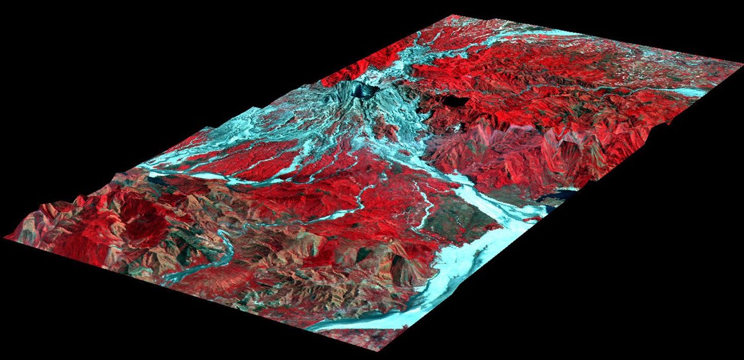


The effects of the June 15, 1991, eruption of Mt. Pinatubo continue toaffect the lives of people living near the volcano on the island ofLuzon in the Philippines. The eruption produced a large amount ofvolcanic debris that was deposited on the flanks of the volcano as partof pyroclastic flows (avalanches of red-hot ash and pulverized rock). This perspective view looking toward the eastshows the western flank of the volcano where most of these pyroclasticflows were deposited.
This debris consists of ash and boulders that mix with water afterheavy rains to form volcanic mudflows called lahars. Lahars are movingrivers of concrete slurry that are highly erosive. They can sweep downexisting river valleys, carving deep canyons where the slopes are steep,or depositing a mixture of fine ash and larger rocks on the gentlerslopes. The deposits left from a lahar soon solidify into a materialsimilar to concrete, but while they are moving, lahars are dynamicfeatures, and in a single river valley the active channel may changelocations within a few minutes or hours. These changes represent asignificant natural hazard to local communities.
The topographic data were collected by NASA’s airborne imaging radarAIRSAR instrument on November 29, 1996. Colors are from the French SPOTsatellite imaging data in both visible and infrared wavelengthscollected in February 1996. Areas of vegetation appear red and areaswithout vegetation appear light blue. River valleys radiate out from thesummit of the volcano (upper center). Since the eruption, lahars havestripped these valleys of any vegetation. The Pasig-Potrero River flowsto the northeast off the summit in the upper right of the image.
Scientists have been using airborne radar data collected by theAIRSAR instrument in their studies of the aftereffects of the Mt.Pinatubo eruption. AIRSAR collected imaging radar data over the volcanoduring a mission to the Pacific Rim region in late 1996 and on afollow-up mission to the area in late 2000. These data sets along withremote sensing data collected from satellites provide valuableinformation on the dynamic landscape and the hazards that it poses.
For more information about lahars on Mt. Pinatubo, readWhen Rivers of Rock Flow andAstronauts Photograph Mt. Pinatubo.
References & Resources
Image courtesy NASA/JPL/University of Hawaii