
Despite their delicate appearance, thin, feathery clouds of ice crystals calledcirrus may contribute to global warming. Some scientists believe cirrus is quitecommon, but it is notoriously difficult to observe—even from satellites,which offer our only means of monitoring such clouds over the entire planet.
The Multi-angle Imaging SpectroRadiometer (MISR), one of a new generation ofinstruments flying aboard the NASA Earth Observing System’s Terra satellite,views Earth with nine cameras simultaneously, some at very steep angles throughthe atmosphere. Scientists on the MISR team have been hoping to learn whatcontributions their instrument can make to a global inventory of cirrus. Theygot their chance to test MISR’s capabilities during July 2002, when they joinedover 400 other scientists and six research aircraft at the US Naval Air Stationnear Key West, Florida for the Cirrus Regional Study of Tropical AnvilsLayers-Florida Area Cirrus Experiment (CRYSTAL-FACE) field campaign. Thecampaign had many goals, one of which was making simultaneous aircraft andsatellite measurements of cirrus.
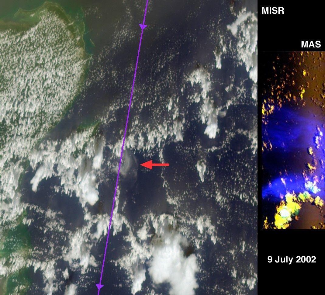
On July 9, the ER-2 research plane, carrying a multi-spectral camera called theMODIS Airborne Simulator (MAS), flew in the stratosphere above a35-kilometer-wide patch of thin cirrus minutes after MISR imaged the cloud fromspace. At the same time, another NASA high-altitude jet, the WB-57, flew rightthrough the 15-kilometer-high cloud with cloud particle counters and a particleimager.
The left side of this montage is a natural-color view of the Caribbean Seaeast of the Yucatan Peninsula as seen by MISR’s most steeply forward-viewingcamera. The thin line running roughly north-south was drawn on this image alongthe flight tracks of the stacked ER-2 and WB-57, and the red arrow points to acrescent-shaped cirrus cloud. At right is a false-color image taken 700kilometers closer to Earth by the MAS instrument on the ER-2. Data from the MAS shortwaveinfrared channel that detects cirrus is shown in blue.
An animation of the cloud as seen by seven of the nine MISR cameras is alsoavailable. It progresses from the most steeply forward to the most steeply backwardview, and excludes imagery from two angles which had significant sunglint. Thesegray-scale images use MISR’s red band. The cirrus is prominent at the steeperangles and virtually disappears in the nearly vertical views. Because it is somuch higher, the cirrus seems to move more than the background clouds. Theanimation also shows the 3-dimensional structure of many towering cumulusclouds. By analyzing these data sets, scientists will learn how effectively theycan use MISR observations to map thin cirrus, and to monitor changes in itsdistribution from season to season and year to year. For more information aboutthe CRYSTAL-FACE campaign, visit: http://cloud1.arc.nasa.gov/crystalface/.
The Multi-angle Imaging SpectroRadiometer observes the daylit Earthcontinuously from pole to pole, and views almost the entire globe every 9 days.This MISR image covers an area of about 232 kilometers x 267 kilometers.
References & Resources
Image courtesy NASA/GSFC/LaRC/JPL, MISR Team and the MAS Teams at NASA Goddard Space Flight Center and Ames Research Center.