Editor’s Note: Today’s caption is the answer to Earth Observatory’s November puzzler.
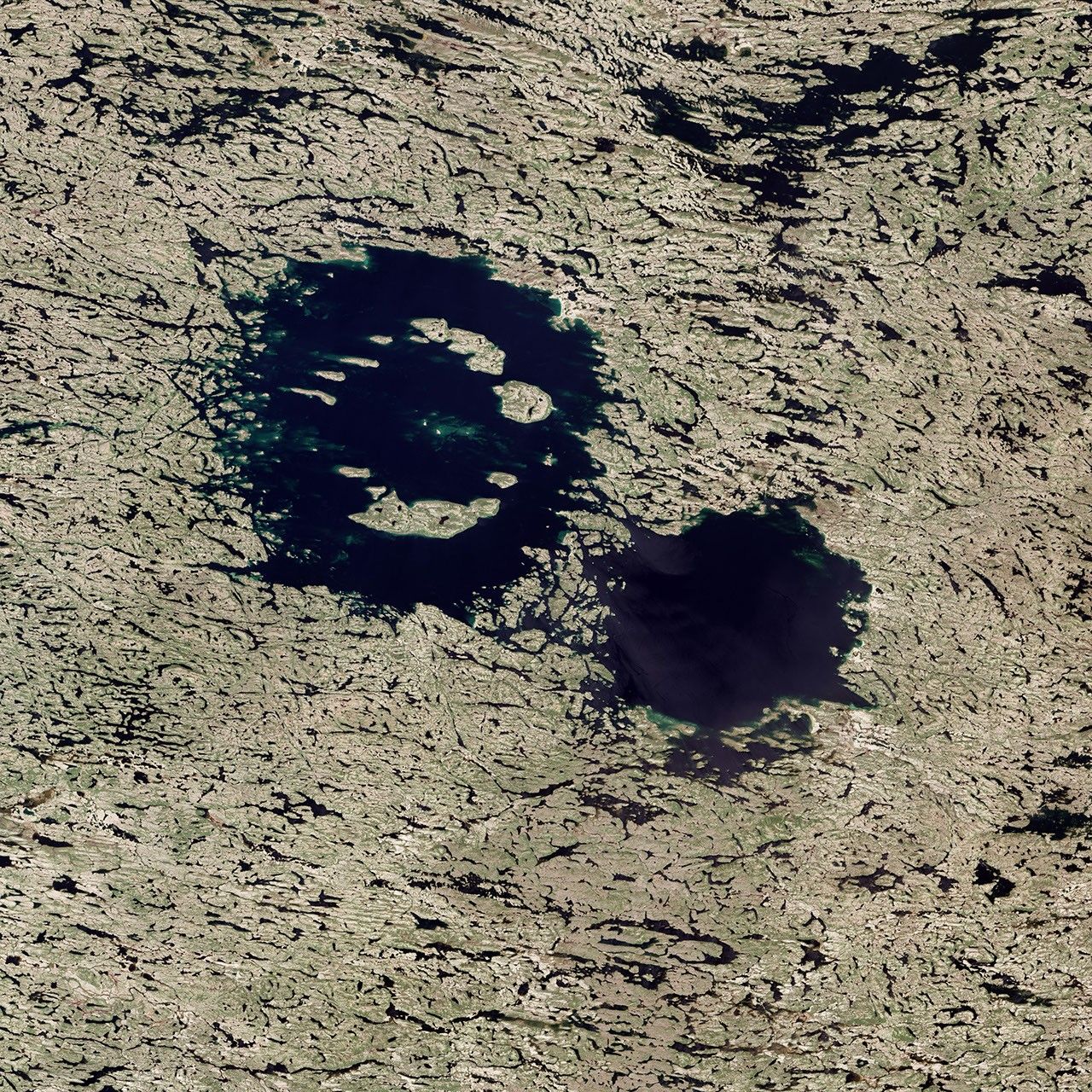
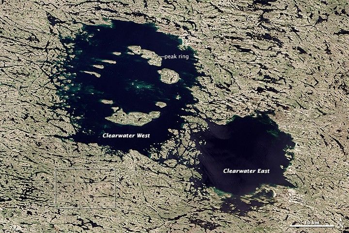
About 290 million years ago, two large asteroids smashed into Earth. The massive craters they left behind—now lakes—are still visible from space. Astronauts have noticed and photographed the craters for decades, and the Operational Land Imager on Landsat 8 captured a new image of Clearwater Lakes (Lac à l‘Eau Claire) on June 29, 2013. The small inset box toward the lower left marks the area shown in the lower image.
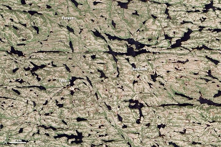
When they struck, the binary asteroids crashed into a part of Earth’s crust that was fairly close to the equator. Since then, millions of years of plate tectonics have pushed the craters north into what is now northwestern Quebec. A mere 20,000 years ago (not long from a geologic perspective), massive sheets of ice covered northwestern Quebec, much like ice now covers Antarctica and Greenland. During that period, ice sheets repeatedly advanced and retreated, scouring the land of soil and rock during cool periods, and then carving deep channels and rinsing the landscape with melt water during warmer periods.
In the images above, the impact of that glacial scouring is evident. The area has little topsoil and supports only sparse vegetation such as spruce forests, grasses, and mosses. The erosion was so complete that many land surfaces were scraped down to underlying bedrock, exposing some of the oldest rocks in the world. Meanwhile, the melt water from retreating glaciers left a dense network of linear lakes and streams that now dominate the surface. Their ubiquity and complexity is a sign that the geologically young drainage network has yet to carve out its most efficient route to the sea.
While simple craters have a circular, bowl-shaped form, large asteroids leave more complex shapes. Clearwater East and Clearwater West, for instance, are both complex craters with distinct central peaks. These peaks are caused by the gravitational collapse of crater walls and subsequent rebound of the compressed crater floor. Lake water covers the central peak of Clearwater East, but bathymetric surveys of the lake floor confirm the presence of a peak in its center.
The central peak on Clearwater West went through another geologic twist. The central peak became so tall that it collapsed, producing a feature known as a peak ring. The top of the peak ring rises well above the modern water line, leaving the ring of islands seen above.
References & Resources
- Encyclopedia of Earth (2007, April 23) Eastern Canadian Shield Taiga. Accessed November 22, 2013.
- Ecological Framework of Canada Ecoregions of Canada: Southern Ungava Peninsula. Accessed November 22, 2013.
- Exploring Earth What if Earth and the Moon Were Hit by Twin Asteroids? Accessed November 22, 2013.
- Lunar and Planetary Institute Impact Cratering. Accessed November 22, 2013.
- Planetary and Space Science Centre Earth Impact Database: Clearwater West. Accessed November 22, 2013.
- Planetary and Space Science Centre Earth Impact Database: Clearwater East. Accessed November 22, 2013.
- Royal Astronomical Society of Canada Clearwater West Impact Crater. Accessed November 22, 2013.
- University of Wisconsin - Green Bay Crater forms. Accessed November 22, 2013.
- U.S. Geological Survey (2009, May 28) The North American Tapestry of Time and Terrain. Accessed November 22, 2013.
NASA Earth Observatory images by Jesse Allen and Robert Simmon, using Landsat 8 data from the USGS Earth Explorer. Caption by Adam Voiland. Congratulations to Allen Pope (NSIDC), D Arseneault, and Lachezar Filchev for coming close to solving the puzzler and for providing interesting background information about the area.