Suggested Searches

1 min read

Activity at Dukono Volcano

Instruments:
Topics:
2016-03-22 00:00:00
March 22, 2016

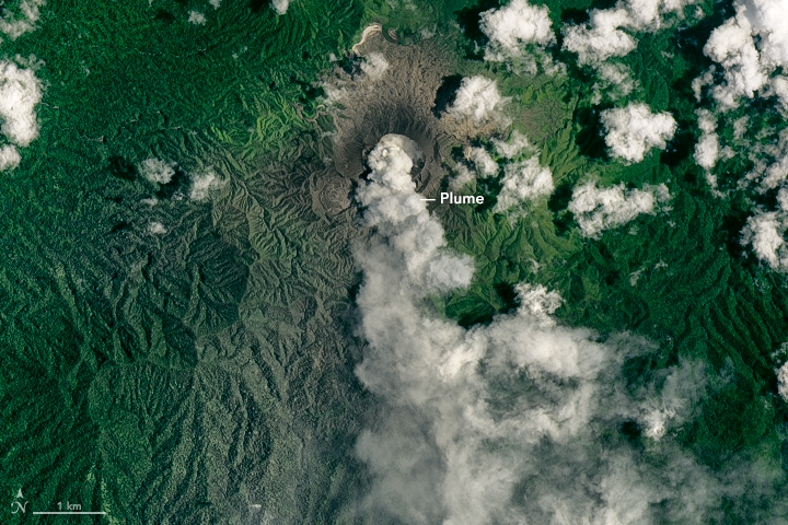
On March 22, 2016, the Operational Land Imager (OLI) on Landsat 8 acquired this image of an ash plume from Dukono, a volcano on a remote Indonesian island.

The volcano is frequently active, according to the Smithsonian Institution’s Global Volcanism Program. During the week leading up to this image, the plume reached as high as 2.4 kilometers (8,000 feet) above sea level.

References & Resources

  • Smithsonian Institution’s Global Volcanism Program (2016, March 22) Dukono. Accessed March 25, 2016.

NASA Earth Observatory image by Joshua Stevens, using Landsat Data from the U.S. Geological Survey . Caption by Kathryn Hansen.

You may also be interested in:

Stay up-to-date with the latest content from NASA as we explore the universe and discover more about our home planet.

Pumice Rafts Encroach on Admiralty Islands
4 min read

Buoyant volcanic rock fragments from an underwater eruption drifted across the Bismarck Sea and choked island coasts.

Article
Anak Krakatau Rumbles Again
3 min read

A powerful eruption from the Indonesian volcano lofted ash into the atmosphere, disrupting thousands of flights and degrading air quality.

Article
A Bright Spot at Mount Michael
3 min read

With austral winter nearing its end, clouds cleared for a satellite view of volcanic activity in the remote South Atlantic.

Article