![Request for Information – Potential [Placeholder for Prize]](https://assets.science.nasa.gov/dynamicimage/assets/science/psd/solar/2023/09/s/solarsystem_0.jpg?w=1024)


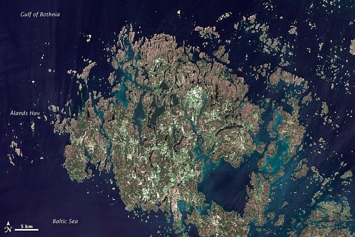
The Åland Islands (also known as the Aaland Islands) lie at the southern end of the Gulf of Bothnia, between Sweden and Finland. The archipelago consists of several large islands and roughly 6,500 small isles, many of them too small for human habitation.
Åland vegetation is a combination of pine and deciduous forest, meadows, and farmed fields. On nearly every island, however, the region’s characteristic red rapakivi granite appears.
Modern residents of Åland cut and use the granite in buildings and pavement, but much earlier, ice sculpted these rocks. About 20,000 years ago, a massive ice sheet stretched over Scandinavia and the Gulf of Bothnia, and glacial action gradually wore the granite smooth.
The granite in this region is actually far older than the glaciers that smoothed its surface, having formed in the Proterozoic Era. The rapakivi was deposited tens of millions of years before the first amphibians crawled out of water and onto land, and hundreds of millions of years before the first dinosaurs evolved.
References & Resources
- Institute of Geology at Tallinn University of Technology. (2010, April 28). Geological History of the Baltic Sea. (PDF file, 12.5 MB) Accessed September 14, 2011.
- Åland Official Tourist Gateway. Accessed September 14, 2011.
- St. John, J. Rapakivi granites. Ohio State University. Accessed September 14, 2011.
NASA Earth Observatory image created by Jesse Allen and Robert Simmon, using Landsat data provided by the United States Geological Survey. Caption by Michon Scott.