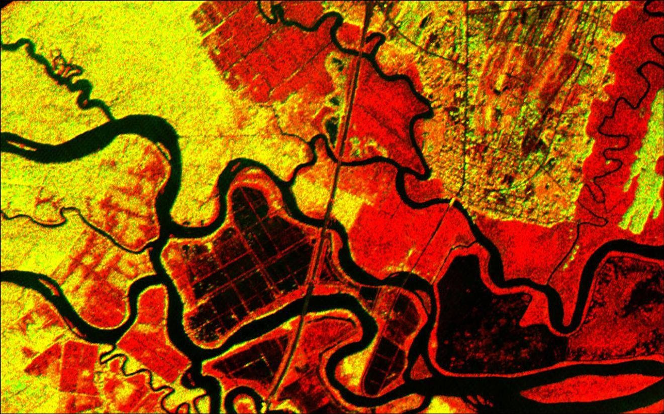
The history of sea islands in the Altamaha River delta on the coast ofGeorgia is revealed in this image produced from data acquired by theAirborne Synthetic Aperture Radar (AIRSAR), developed and operated byNASA's Jet Propulsion Laboratory, Pasadena, Calif. The outlines oflong-lost plantation rice fields, canals, dikes and other inlets areclearly defined. Salt marshes are shown in red, while dense cypress andlive oak tree canopies are seen in yellow-greens.
Agricultural development of the Altamaha delta began soon after thefounding of the Georgia Colony in 1733. About 25 plantations werelocated on the low-lying islands and shores by the 19th century, takingadvantage of the rich alluvial flow and annual inundation of waterrequired by some crops. The first major crop was indigo; when demand forthat faded, rice and cotton took its place. A major storm in 1824destroyed much of the town of Darien (upper right) and put many of theislands under 20 feet of water. The Civil War ended the plantationsystem, and many of the island plantations disappeared under heavy brushand new growth pine forests. Some were used as tree farms for paper andpulp industries, while the Butler Island (center left) plantation becamea wildlife conservation site growing wild sea rice for migrating ducksand other water fowl. Margaret Mitchell is reputed to have used theformer owner of the Butler Plantation as a basis for the Rhett Butlercharacter in her novel "Gone With The Wind," taking the first name fromRhett's Island (lower right).
These data were obtained during a 1994-95 campaign along the Georgiacoast. AIRSAR's ability to detect vegetation canopy density,hydrological features and other topographic characteristics is a usefultool in landscape archaeology. AIRSAR flies aboard a NASA DC-8 based atNASA's Dryden Flight Research Center, Edwards, Calif. The analysis onthe data shown was accomplished by Dr. Gary McKay, Department ofArchaeology and Geography, and Ian Morrison, Department of Archaeology,both of the University of Edinburgh (Scotland). AIRSAR is part of NASA'sEarth Enterprise program. JPL is managed by the California Institute ofTechnology, Pasadena.
References & Resources
Image courtesy NASA/JPL/University of Edinburgh