About a month after a powerful atmospheric river brought abundant rain to coastal British Columbia, another storm drenched southern parts of the Canadian province and western Washington in the U.S.
The atmospheric river made landfall over British Columbia on October 18, 2024, and moved down the coast on October 19-20. Portions of southern Vancouver Island recorded up to 300 millimeters (12 inches) of rain between October 18 and 20, while the Vancouver metropolitan area on the mainland received up to 150 millimeters (6 inches). According to the Vancouver Sun, the rain overwhelmed the city’s storm drain system, leading to widespread flooding.
Toward the south, the storm also brought rain and wind to portions of western Washington. Up to 150 millimeters of rain was also measured on the Olympic Peninsula. Gusty winds toppled trees and contributed to 14,500 households in the Puget Sound region briefly losing power on October 19. NASA-led research has shown that atmospheric rivers are associated with the most damaging storms in the middle latitudes, especially with regard to the hazardous wind they produce.
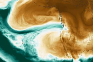
A second pulse of water vapor moved over southwest British Columbia and northern Washington on October 20, when the VIIRS (Visible Infrared Imaging Radiometer Suite) on the NOAA-21 satellite acquired this image. In the image, an elongated stream of water vapor—the hallmark of atmospheric rivers—had reached the western coast of North America after crossing the Pacific Ocean. When atmospheric rivers encounter land, they often release that water vapor in the form of rain or snow.
According to the Center for Western Weather and Water Extremes at the University of California, San Diego, forecasters expected the atmospheric river to hit western Canada as a Category 3 or 4 event, the second- and third-highest tiers on the scale. The storm follows an unusually strong Category 5 atmospheric river that hit British Columbia in September 2024. Experts suspect that the September atmospheric river was among the most intense events to transit the northeast Pacific in a satellite-based record going back to 2000.
References & Resources
- Center for Western Weather and Water Extremes (2024, October 18) Quick Look at the Strong AR Forecast to Impact British Columbia and the Pacific Northwest. Accessed October 21, 2024.
- NASA Earth Observatory (2024, September 28) An Uncommonly Strong Atmospheric River. Accessed October 21, 2024.
- National Weather Service, Seattle (2024, October 20) Here’s a look at the 36 hour rainfall totals across western WA - ending at 5am this morning. Accessed October 21, 2024.
- Vancouver Sun (2024, October 19) B.C. storm weather updates: Body found in Coquitlam mudslide | Weather warnings over as cleanup continues | Six homes under evacuation order in Deep Cove. Accessed October 21, 2024.
- Vancouver Sun (2024, October 19) Photos: Atmospheric river brings heavy rain, flooding to Metro Vancouver. Accessed October 21, 2024.
- Waliser, D., Guan, B. (2017) Extreme winds and precipitation during landfall of atmospheric rivers. Nature Geoscience 10, 179-183.
- The Weather Network (2024, October 20) How impactful was B.C.’s latest atmospheric river? Details pour in. Accessed October 21, 2024.
NASA Earth Observatory image by Wanmei Liang , using VIIRS data from NASA EOSDIS LANCE , GIBS/Worldview , and the Joint Polar Satellite System (JPSS). Story by Emily Cassidy .

