Today’s story is the answer to the May puzzler.
Looking down from space, the human presence is starkly apparent in the way we light our cities, transport our manufactured products, and grow our food. Even the way we play is visible from hundreds of miles above.
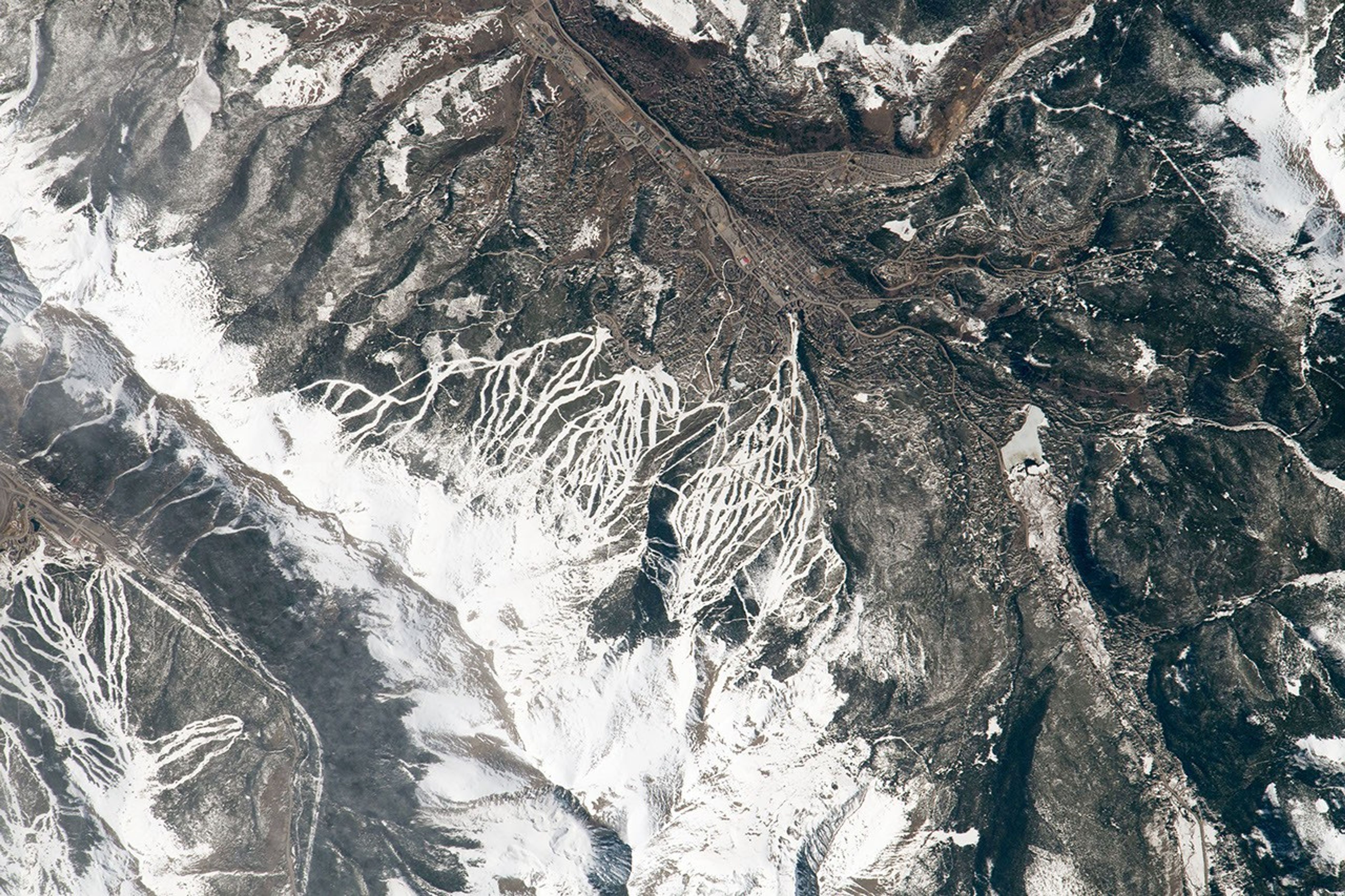
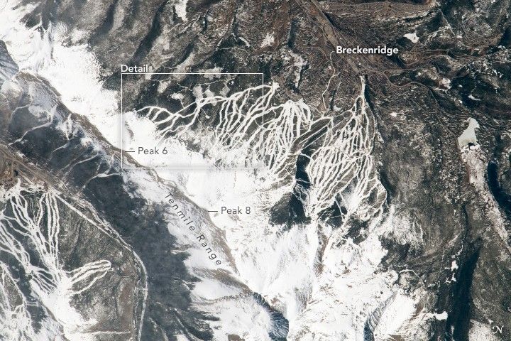
On May 1, 2021, an astronaut onboard the International Space Station shot this photograph of Breckenridge Ski Resort in Colorado. More than 100 trails sweep down the eastern side of Tenmile Range, a portion of the Southern Rocky Mountains located about 60 miles (100 kilometers) west-southwest from Denver. Part of the Copper Mountain resort is also visible in the lower-left corner.
Notice that even in May, the trails are still blanketed in white. This is typical for the Tenmile Range, which retains snow at higher elevations into the summer months. As of mid-May, the snow water equivalent—the depth of water in the snowpack if it were all melted—was very close to the 1981–2010 average in the Breckenridge and Copper Mountain areas. That’s not the case everywhere, however, and the state’s varied topography can lead to vastly different amounts of snow cover.
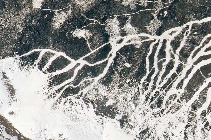
The Tenmile Range is named for the distance spanned by 10 of the range’s peaks, each about a mile apart and named in numerical order. The slopes of five of these peaks—Peak 6 through Peak 10—are within the Breckenridge resort. Peak 8 was the first to be developed and opened to skiers in December 1961. Peak 8 Ski Area, as it was named at the time, consisted of 1,764 acres, one chair lift, and fewer than 10 trails. Since then, Breckenridge Ski Resort has expanded to nearly 3,000 skiable acres, 34 chair lifts, and 191 trails.
More than 500 of those acres opened to skiers and snowboarders for the 2013-2014 winter season following the development of Peak 6, visible in the detailed view above. The additional runs—not yet present when we last showed the area in 2008—are visible where they cut through the forest. At higher elevations, Peak 6 trails include the area’s first bowl-shaped terrain above the tree line rated for intermediate skiers.
The U.S. Forest Service had to deliberate carefully before deciding to approve projects on Peak 6. Land managers had to weigh public and economic benefits against potential effects that forest removal could have on lynx habitat, water resources, and overall forest health. Breckenridge is not alone, as many other ski resorts across Colorado currently look to expand .
References & Resources
- The Aspen Times (2020, November 11) More expansion eyed by ski areas in Colorado. Accessed May 14, 2021.
- Base Mountain Sports (2020, March 13) Breckenridge Peak 6âEverything You Need to Know. Accessed May 14, 2021.
- Breckenridge Ski Resort Breckenridge Ski Resort History. Accessed May 14, 2021.
- Breckenridge Ski Resort Trail Map. Accessed May 14, 2021.
- Colorado State University Climate. Accessed May 14, 2021.
- Elevation Outdoors (2011, October 31) Pushing the Boundaries. Accessed May 14, 2021.
- The Gazette (2014, January 16) Opening of Peak 6 gives Breckenridge a new gem. Accessed May 14, 2021.
- NASA Earth Observatory (2008, December 29) Breckenridge and Copper Mountain Ski Slopes, Colorado.
- Natural Resources Conservation Service (2021, May 13) Ski West Report SNOTEL Snow/Precipitation Update Report. Accessed May 13, 2021.
- Summit Daily (2015, January 9) Quandary on Tenmile peak names, Summit Countyâs record snowfalls. Accessed May 14, 2021.
- To the Mountains Blog (2013, October 17) Breckenridge Peak 6 Expansion Means More Skiable Acres. Accessed May 14, 2021.
- Twitter (2021, May 6) Shane Kimbrough. Accessed May 14, 2021.
- U.S. Forest Service (2012, August) Peak 6 Project Final Environmental Impact Statement, Record of Decision. Accessed May 14, 2021.
Astronaut photograph ISS065-E-13520 was acquired on May 1, 2021, with a Nikon D5 digital camera using an 1150 millimeter lens and is provided by the ISS Crew Earth Observations Facility and the Earth Science and Remote Sensing Unit, Johnson Space Center. The image was taken by a member of the Expedition 65 crew . The image has been cropped and enhanced to improve contrast, and lens artifacts have been removed. The International Space Station Program supports the laboratory as part of the ISS National Lab to help astronauts take pictures of Earth that will be of the greatest value to scientists and the public, and to make those images freely available on the Internet. Additional images taken by astronauts and cosmonauts can be viewed at the NASA/JSC Gateway to Astronaut Photography of Earth . Story by Kathryn Hansen .