
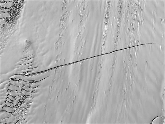

A large tabular iceberg (42 kilometers x 17 kilometers) broke offPine Island Glacier, West Antarctica (75°S latitude, 102°W longitude)sometime between November 4 and 12, 2001. Images of the glacier wereacquired by the Multi-angle Imaging SpectroRadiometer (MISR) instrumentaboard NASA’s Terra spacecraft. This event was preceded by the formationof a large crack across the glacier in mid 2000. Data gathered by otherimaging instruments revealed the crack to be propagating through theshelf ice at a rate averaging 15 meters per day, accompanied by a slightrotation of about one percent per year at the seaward margin of therift.
The image set shows three views of Pine Island Glacier acquired byMISR’s vertical-viewing (nadir) camera. The first was captured in late2000, early in the development of the crack. The second and third viewswere acquired in November 2001, just before and just after the newiceberg broke off. The existence of the crack took the glaciologicalcommunity by surprise, and the rapid rate at which the crack propagatedwas also not anticipated. Glaciologists predicted that the rift wouldreach the other side of the glacier sometime in 2002. However, theiceberg detached much sooner than anticipated, and the last 10-kilometersegment that was still attached to the ice shelf snapped off in a matterof days.
The animated sequence consists of 11 snapshots acquired by MISR’snadir camera between September 16, 2000 and November 12, 2001. Due tofrequent cloud cover, the time interval between successive frames is notuniform. The flow of the glacier, widening of the rift, and subsequentbreak-off of the iceberg are evident. A “jump” in the position of therift near the middle of the sequence is due to a gap in imageacquisition during Antarctic winter, when the glacier was in continuousdarkness.
Pine Island Glacier is the largest discharger of ice in Antarcticaand the continent’s fastest moving glacier. This area of the WestAntarctic Ice Sheet is also believed to be the most susceptible tocollapse. The evolution of this glacier is therefore of great interestto the scientific community. “The climatic significance of this calvingevent is not yet clear, but is taking place in an area of Antarcticawhich is experiencing rapid changes”, said glaciologist Eric Rignot ofthe Jet Propulsion Laboratory. Rignot points out that the grounding lineof Pine Island Glacier is retreating, the glacier is thinning rapidly,and its ice flow is accelerating. Additionally, the sea ice cover infront of the glacier has been decreasing steadily for several decades.The newly hatched berg represents nearly seven years of ice outflow fromPine Island Glacier released to the ocean in a single event. Althoughthis has no effect on sea level (the ice is already afloat), it is anexceptional event for this glacier, and provides additional evidencethat this area is undergoing rapid change.
References & Resources
Image courtesy NASA/GSFC/LaRC/JPL, MISR Team.