
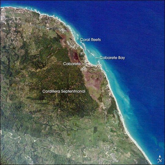
The Dominican Republic occupies the eastern two-thirds of the island of Hispaniola in the Caribbean Sea. The island has a variety of ecosystems ranging from arid plains to tropical rain forests created by three roughly parallel east-west mountain ranges. The northernmost of these ranges, the Cordillera Septentrional, is visible in this astronaut photograph as the dark green region north of the river. Clearcut regions within the Cordillera Septentrional are visible as irregular light green regions interspersed with dark green forested areas.
The northern coastline of the Dominican Republic in this image is a major tourist attraction due to its extensive beaches and coral reefs. Besides recreational opportunities, coral reefs provide protection for bays and critical habitat for numerous economically important marine species.
Cabarete Bay, a popular destination for surfers and divers, is formed by a barrier coral reef. Increased development of the city of Cabarete and deforestation of upland regions has resulted in increased urban and sediment runoff into the bay and impacted the health of the coral reefs. Overfishing of the coral reefs during the 1980s has also contributed to a decline in ecosystem function.
Environmental stress on the Dominican coral reefs is not due solely to human activities. Three major hurricanes have hit Hispaniola during the last 25 years, leading to direct physical destruction of coral reefs as well as large sediment pulses into coastal waters from debris flows (mudslides) and slope failures. Paradoxically, tourism in the Dominican Republic has helped alleviate one aspect of stress on the reefs. Many fishermen now work in tourist hotels for higher pay, decreasing fishing pressure on the coral reefs.
References & Resources
Astronaut photograph ISS009-E-12329 was acquired June 17, 2004 with a Kodak K60C digital camera with a 400 mm lens, and is provided by the Earth Observations Laboratory, Johnson Space Center. The International Space Station Program supports the laboratory to help astronauts take pictures of Earth that will be of the greatest value to scientists and the public, and to make those images freely available on the Internet. Additional images taken by astronauts and cosmonauts can be viewed at the NASA/JSC Gateway to Astronaut Photography of Earth.