


Residents of the U.S. Midwest and eastern states might have noticed that the Sun appeared to have a slightly different hue in early June 2015. It was not your imagination. Smoke from wildfires in Canada cast a hazy mask over the atmosphere that gave the Sun a deeper orange-red color.
The Moderate Resolution Imaging Spectroradiometer (MODIS) on NASA’s Terra satellite captured this natural-color view of the smoke plume as it passed over Wisconsin, Michigan, Indiana, Ohio, and West Virginia on the morning of June 9, 2015. Smoke reached Mid-Atlantic states by that evening and persisted there on June 10.
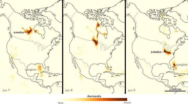
The series of images below shows the plume’s movement. They wereacquired by the Ozone Mapping Profiler Suite (OMPS) on the Suomi NPP satellite. Smoke from fires burning in Alberta, Canada, is visible on June 7 over Canada’s Saskatchewan and Manitoba provinces (left). The smoke entered the United States over Minnesota on June 8 (middle), and then moved over the Midwest on June 9 (right).
“Smoke like this is quite common in the northern hemisphere high latitudes due to large wildfires in places like central Canada, Alaska, and Siberia,” said National Oceanic and Atmospheric Administration (NOAA) research meteorologist Dan Lindsey. “Under the proper atmospheric flow conditions, sometimes the smoke will advect over the United States, as it did in this case.”
NOAA research meteorologist Mark Ruminski agreed that it’s common to see smoke in northern latitudes, and also in the western United States, where large areas of forest are prone to burning. It’s less common to see thick plumes move into the Ohio Valley and Mid-Atlantic. “It’s not unprecedented, but smoke this thick is not common in these parts,” he said.
Ruminski recalls two previous episodes when a significant amount smoke from fires in Canada entered the United States. In May 2010, a thick plume from fires in Quebec made it to New England. And before that in July 2002, thick smoke (also from fires in Quebec) entered the eastern United States.
The June 2015 plume was at an altitude of about 2 to 5 kilometers (7,000 to 16,000 feet). That could mean reduced visibility and deteriorated conditions for some aircraft pilots.
References & Resources
- Chicago Tribune (2015, June 9) Forest fires in Canada giving sun ‘unearthly’ look. Accessed June 10, 2015.
- NASA Earth Observatory (2010, June 11) Smoke Over the Mid-Atlantic.
- NASA Earth Observatory (2010, June 2) Canadian Fires Send Smoke Over New England.
- NASA Earth Observatory (2002, July) Smoke from Canadian Fires Blankets Eastern U.S.
- NASA Ozone Mapping & Profiler Suite (2015, June 10) Smoke From Alberta, Canada to Washington, DC. Accessed June 10, 2015.
- WISN Milwaukee (2015, June 9) Why is the sun so red today? Canadian wildfires to blame. Accessed June 10, 2015.
NASA Earth Observatory image by Jesse Allen, using Terra MODIS data from the Land Atmosphere Near real-time Capability for EOS (LANCE) and Suomi NPP OMPS data courtesy of Colin Seftor (SSAI). Suomi NPP is the result of a partnership between NASA, NOAA and the Department of Defense. Caption by Kathryn Hansen.


