


Scientists for the first time ever can simultaneously measure the heightand motion of clouds over Earth from pole to pole, which may improveweather forecasts.
Never before have researchers directly measured cloud heights from asingle satellite, simultaneously measured cloud heights and winds, anddone this above Earth’s polar regions as well as lower latitudes.
Professor Roger Davies and graduate research assistant Akos Horvath ofthe University of Arizona, Tucson, report first results on cloud windsand heights from NASA's polar-orbiting Terra satellite’s Multi-angleImaging SpectroRadiometer (MISR) in the Aug. 1 issue of Geophysical ResearchLetters.
Simultaneous measurement of cloud heights accurate to within 400 meters(about 1,300 feet) and cloud winds accurate to within 3 meters (about 10feet) per second anywhere over the globe is a potential boon formeteorology, Davies said. While Terra is a research satellite, not anoperational satellite, the success of the radiometer’s fully automatedmulti-angle imaging technique “pioneers the possibility of deploying anoperational satellite to gain wind information within the atmosphere,especially over the data-sparse areas of the oceans, for improvedweather forecasts,” he said.
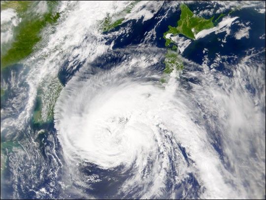
The image above is an example of MISR’s capabilities. Wind vectors aresuperimposed on a visible light image of a cyclone over the northeast PacificOcean. (Wind is blowing in the direction the flag "poles" are pointing.) ‘Barbs’ indicate wind speed. Each half barb represents a windspeed of 5 meters per second, a full barb is 10 meters per second, and a flagis 50 meters per second. Color corresponds to cloud height.
For more information, read NASA Gives Pole-To-Pole View of Cloud Heights and Winds
References & Resources
Image courtesy Roger Davies and Akos Horvath, University of Arizona Radiation, Clouds and Climate Laboratory based on data from the NASA/GSFC/LaRC/JPL, MISR Team.
None


