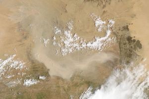
Just four days after one of the worst dust storms in Australian history, another intense storm blew across eastern Australia. The storm sent a thick wall of dust east across Queensland and New South Wales toward the Pacific Ocean. This image, captured by the Moderate Resolution Imaging Spectroradiometer (MODIS) on NASA’s Terra satellite on September 26, 2009, shows a portion of the storm over the border between the two states.
Like the cloud of dust that developed on September 23, this dust plume is thick. The tan-orange cloud obscures the ground entirely. Red squares mark the locations of active fires near the right edge of the image.
The large image provided above is at MODIS’ maximum resolution of 250 meters per pixel. The MODIS Rapid Response System provides the image in additional resolutions.
References & Resources
NASA images courtesy Jeff Schmaltz, MODIS Rapid Response Team at NASA GSFC. Caption by Holli Riebeek.