


























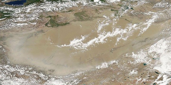
Dust plumes fringed the southwestern rim of the Taklimakan Desert on July 18, 2009, as the Moderate Resolution Imaging Spectroradiometer (MODIS) on NASA’s Aqua satellite passed overhead. The dust appears as a fuzzy beige semi-oval in this true-color image. Thinner dust plumes also appear along the southeastern edge of the desert.
The Taklimakan Desert rests the Tarim Basin, a depression between the mountain ranges of the Tien Shan (or Tian Shan) in the north and the Kunlun Shan in the south. The Taklimakan Desert is China’s biggest, hottest, and driest desert, and it is one of the world’s largest shifting-sand deserts, with dunes reaching a height of as much as 200 meters (656 feet). What little water reaches the Tarim Basin finds no outlet, leading to the buildup of extensive salt deposits.
References & Resources
- World Wildlife Fund, McGinley, M. (2007). Taklimakan Desert. Encyclopedia of Earth. Accessed July 20, 2009.
NASA image courtesy MODIS Rapid Response Team, Goddard Space Flight Center. Caption by Michon Scott.