

Food production is influenced by myriad conditions: Weather that is too dry, too wet, too hot, or too cool can severely affect a farmer's ability to grow crops. A NASA and USAID supported-project called the GEOGLAM Crop Monitor for Early Warning is working to anticipate decreases in crop yields during the growing season and ahead of harvest by examining weather-related satellite data.
“There’s a pressing need for better and more reliable information for crop conditions in countries concerned with food security,” said Christina Justice, remote sensing expert at the University of Maryland and coordinator for the GEOGLAM Crop Monitor for Early Warning project.
Food security—or having access to enough food to sustain a healthy, well-nourished diet—is a priority in many nations around the world. Since 2014, the number of undernourished people in the world has been increasing because of inadequate access to food. The project brings together international food security monitoring agencies and regional organizations to provide crop analyses for 81 countries. Using satellite observations, meteorological information, field observations, and ground reports, the project examines conditions affecting dominant crops for each region, such as rice in Southeast Asia or maize in Central America.
The maps on this page show Normalized Difference Vegetation Index (NDVI) anomalies, one of several satellite-derived products used to assess crop conditions. NDVI measures the health, or “greenness,” of vegetation based on how much red and near-infrared light the leaves reflect. Healthy vegetation reflects more infrared light and less visible light than stressed vegetation. Both maps show NDVI from June to August 2018 compared to the average from June to August over 2000 to 2013. The data was provided by Moderate Resolution Imaging Spectroradiometer (MODIS) on NASA's Terra satellite.
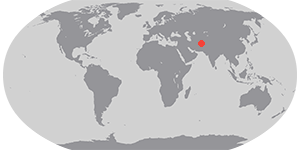
The top map shows one of the areas where crop conditions for 2017/18 was most affected: Afghanistan. Sparse rain and snowfall in Afghanistan over the past year have created drought conditions that are reducing crop yields. Reports say more Afghans have been displaced by drought conditions than conflict this year.
The biggest decrease in vegetative greenness occurred in northern Afghanistan, where approximately 20 percent of the country's total wheat is grown. For spring wheat (wheat planted in the spring, harvested in the fall in the northern hemisphere), the GEOGLAM Crop Monitor classified parts of northern Afghanistan as “failure”—the most severe category—meaning crop yields are likely to be at least 25 percent below average. Conditions for winter wheat (sown in the winter, harvested in the summer) have been classified as “poor,” meaning yields are likely to be 10 to 25 percent below average. Afghanistan can import wheat from neighboring Pakistan and Kazakhstan.
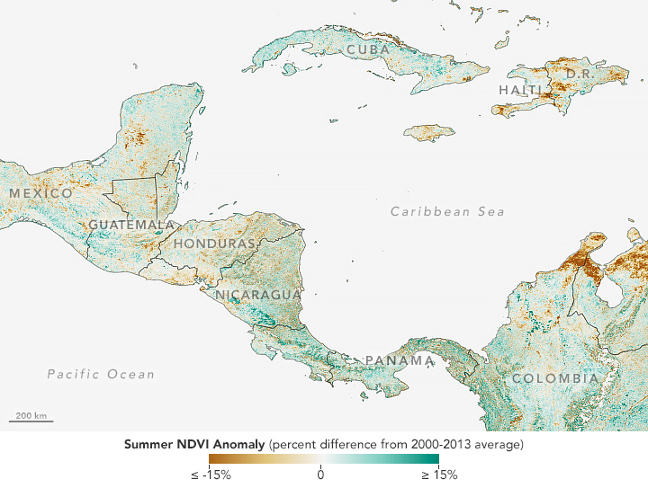
The map above shows NDVI anomalies in Central America and the Caribbean. A severe drought spread across southern Mexico to Panama. In July, affected areas in Guatemala, El Salvador, and Honduras experienced maize and bean losses from 75 to 100 percent. The Crop Monitor has largely classified maize conditions in Guatemala and Honduras as “failure” while yields in Haiti and El Salvador have mainly been classified as “poor.”
“NDVI is an important tool for monitoring crop conditions for food security,” said Justice. “Any changes in precipitation and temperature will have an effect on vegetative greenness.”
The Crop Monitor compiles all the different types of crop condition indicators—including NDVI, temperature, precipitation, and soil moisture, among others—and shares them with 14 national and international partners. The partners help corroborate the findings with their own satellite data and on-the-ground reports to build consensus on the current crop conditions and summarize them in a monthly bulletin.
Some of the partner organizations, such as the Famine Early Warning Systems Network (FEWS NET) and the United Nations World Food Programme, are directly connected to rescue efforts. Funded by the U.S. Agency for International Development (USAID), FEWS NET provides crop condition information for relief efforts. Other partners of the GEOGLAM Crop Monitor for Early Warning project include the Food and Agricultural Organization and the Joint Research Centre. You can find this month’s updated crop conditions and more information on the Crop Monitor website.
References & Resources
- Crop Monitor: A GEOGLAM initiative. Accessed October 4, 2018.
- Crop Monitor (2018, October) Crop Monitor for Early Warning. Accessed October 4, 2018.
- Food and Agriculture Organization of the United Nations (2018) The State of Food Security and Nutrition in the World. Accessed October 4, 2018.
- NASA Earth Observatory (2018, March 20) Record Low Snowpack in Afghanistan.
- Relief Web (2018, August 17) Central America: Drought- Information Bulletin N°1. Accessed October 4, 2018.
- Reuters (2018, September 11) More Afghans displaced by drought than conflict, U.N. says.
- USDA Foreign Agriculture Service (2018, May 31) Commodity Intelligence Report.
NASA Earth Observatory images by Lauren Dauphin, using MODIS data from NASA EOSDIS/LANCE and GIBS/Worldview . Story by Kasha Patel.