Summer bushfires near densely-populated areas in southern Australia attract the most public attention, but the continent’s largest and most frequent fires actually occur in the spring in the tropical savannas of northern Australia.
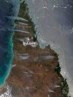
On November 25, 2012, the Moderate Resolution Imaging Spectroradiometer (MODIS) aboard NASA’s Aqua satellite captured this natural-color image of wildfires burning on Cape York Peninsula, the northernmost part of Australia. Smoke plumes from multiple fires are visible streaming west; red outlines indicate hot spots where MODIS detected unusually warm surface temperatures associated with fires.
Three main meteorological variables affect fire behavior: atmospheric humidity, air temperature, and wind strength. On Cape York Peninsula, humidity drops and temperatures rise beginning with the arrival of the dry season in March. By the end of November, grasses and woodland trees in the region have reached their most flammable state. In this case, steady winds (about 20 kilometers/12 miles per hour) have helped sustain fires that were likely started by lightning and human activity.
About half of the savanna woodlands on Cape York Peninsula burn either every year or so, typically late in the dry season. Dried grasses, which receive ample sunshine and rain during the wet season, provide the bulk of the fuel. As the dry season progresses, trees also drop loads of leaves and twigs that help fuel fires. Key grasses and trees in the region include Sorghum, Eucalyptus, and Corymbia.
Despite the frequency of the burning, wildfires on Cape York Peninsula are generally less severe than in southern Australia because fungi, bacteria, and other decomposers that thrive in the region continuously break dried grass and leaf litter down. Fewer decomposers live in southern Australia, making it possible for leaf litter and other fuel to build up for decades and prime the landscape for extremely destructive fires.
Further Reading
- CSIRO. (2012, Oct. 26). Bushfire in Australia. Accessed Nov. 27, 2012.
- Crowley, G.M. (2008, Oct. 9). Changing fire management in the pastoral lands of Cape York Peninsula of northeast Australia. Geographical Research.
References & Resources
- NAFI. (2012, Nov. 27) North Australia fire information map: Cape York. Accessed Nov. 27, 2012.
- NASA. (2012, Nov. 27) Cape York Peninsula fires. Accessed Nov. 27, 2012.
- Queensland Government. (n.d.) Rural fire service. Accessed Nov. 27, 2012.
- Savannah Explorer. (n.d.) Fire in Australia’s tropical savannas. Accessed Nov. 27, 2012.
NASA image courtesy Jeff Schmaltz, LANCE MODIS Rapid Response Team at NASA GSFC. Caption by Adam Voiland.