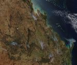


















Scores of fires were burning in southern Queensland on November 17, 2006, when the Moderate Resolution Imaging Spectroradiometer (MODIS) on NASA’s Aqua satellite passed overhead and captured this image. Places where MODIS detected actively burning fires are marked in red. Some of the fires, such as one on Fraser Island at far right in the image, are generating thick plumes of smoke. In this part of Queensland, outcrops of low, forested mountains (dark greenish-brown) mingle with savanna (tan) and croplands (green) at lower elevations.
The Queensland government issued a fire alert on November 16, warning residents to be extra cautious about fire around bushland and grassland areas because dry, windy conditions were creating an elevated fire risk.
The high-resolution image provided above has a spatial resolution of 250 meters per pixel. The MODIS Rapid Response System provides this image at additional resolutions.
References & Resources
NASA image courtesy the MODIS Rapid Response Team, Goddard Space Flight Center