


browse image of orbit 16421 (190 KB JPEG)
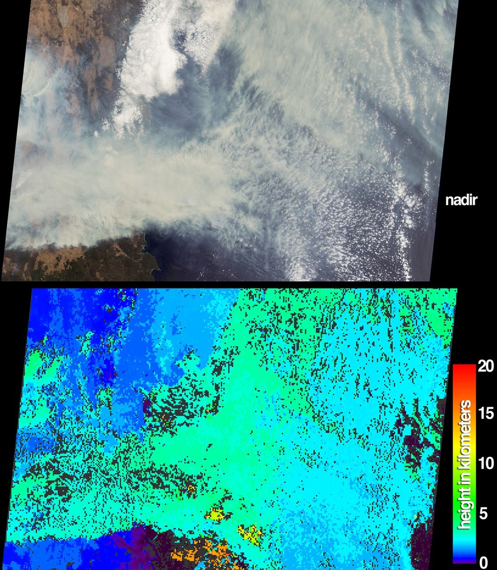
The height and extent of billowing smoke plumes from bushfires nearCanberra, the Australian capital, are illustrated by these views fromthe Multi-angle Imaging SpectroRadiometer (MISR). The images wereacquired on January 18, 2003. Never before had fires of this magnitudecome so close to Australia’s capital. Four people lost their lives andover 500 homes were destroyed, mostly in the southwestern suburbs.Australia’s famous Mount Stromlo Observatory, located immediately westof the city, was also incinerated by the fires.
The top panel portrays a natural-color view from MISR’s nadir camera, inwhich the eastern portion of the Australian Capital Territory is locatedsouth of a pale, ephemeral lake in the upper left-hand corner (LakeGeorge). Several smoke plumes originate within the eastern part of theAustralian Capital Territory, while the major plumes originate to thewest of the image area. The Australian Capital Territory and much of NewSouth Wales are completely obscured by the smoke, which is driven byfierce westerly winds and extends eastward to the coast and over thePacific Ocean.
The lower panel provides a stereoscopically retrieved height field ofthe clouds and smoke plumes. The greenish areas indicate where smokeplumes extend several kilometers above a bank of patchy stratus cloudsbelow. A few high clouds appear near the bottom of the image. Windretrievals were excluded from this image in order to generate a smoothand continuous field. Although relative height variations arewell-represented here, the inclusion of wind retrievals for this scenereduces the actual cloud height results by 1 to 2 kilometers. Areaswhere heights could not be retrieved are shown as dark gray.
The Multi-angle Imaging SpectroRadiometer observes the daylit Earthcontinuously and every 9 days views the entire globe between 82 degreesnorth and 82 degrees south latitude. The MISR Browse Image Viewer provides access tolow-resolution true-color versions of these images. This data product was generatedfrom a portion of the imagery acquired during Terra orbit 16421. Thepanels cover an area of 380 kilometers x 253 kilometers, and utilizedata from blocks 118 to 120 within World Reference System-2 path 89.
References & Resources
Image courtesy NASA/GSFC/LaRC/JPL, MISR Team. Text by Clare Averill (Acro Service Corporation/Jet Propulsion Laboratory)


