


full-size images:
Angola and the Democratic Republic of the Congo (1.2 MB)
Madagascar (2 MB)
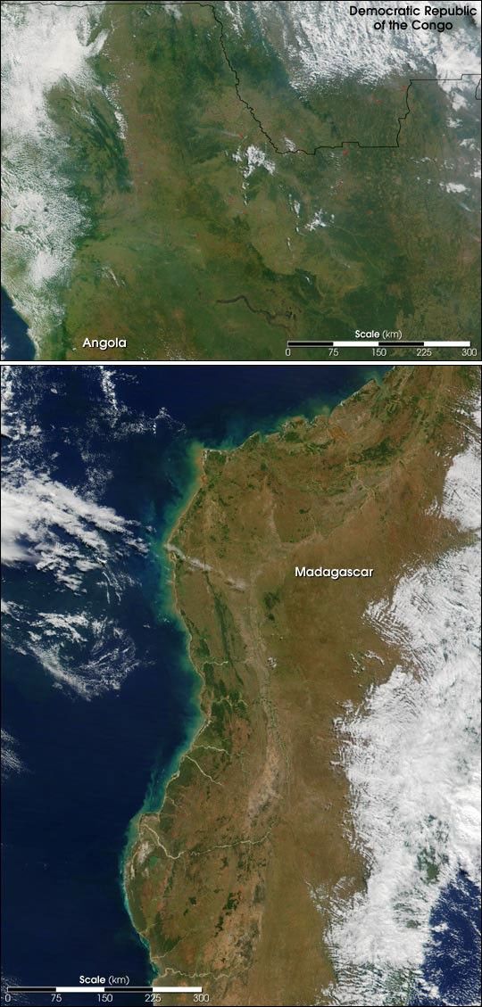
There are currently a large number of fires burning intropical countries around the world. Most recently, theModerate-resolutionImaging Spectroradiometer (MODIS) obtained theserelatively cloud-free looks at Madagascar and Southern Central Africa,revealing quite a few fires across those regions.
The top scene is a true-color image spanning across northernAngola and into the southernmost portion of the Democratic Republic ofthe Congo, in south central Africa. MODIS acquired this scene on May16, 2001. The collective haze produced by the many fires (red pixels,more easil seen in the full-size image)appears to be quite thick toward the northeastern corner of the image,along the border between Angola and the Congo.
The dark ribbon-like feature toward the bottom of this image marksthe northern edge of the Luando Nature Reserve in Angola. Lookingclosely at this feature, it appears as if the Luando River is in flood;or, perhaps this is a marshy zone along the Luando River that is proneto standing water in the wake of the rainy season. The Cuanza Rivermarks the southern boundary of the Luando Nature Reserve.
The bottom scene is a true-color image of the island nation ofMadagascar—located off the east coast of Mozambique—acquired on May13, 2001. While the east side of the island is hidden by clouds, thecentral and west side of Madagascar had dozens of fires (red pixels)burning across what is an already extensively deforested landscape.Fires generally burn with less intensity in the morning, producing lesssignificant smoke plumes than in the afternoon when they heat up.Toward the northwest of the island, notice the rich browns of erodedsoil in the water where the Betsiboka and Ikopa Rivers empty into theMozambique Channel. Without the roots of what was once a thick canopyof vegetation, the soil has nothing to cling to and is therefore easilyswept downstream during rainy seasons.
Tracing southward along Madagascar’s west coastline, notice thesediment coloring the water turquoise. Toward the southern end of theisland, the waters of the Onilahy River empty into the Bay of Saint Augustin. About 200 km (120miles) north of the Onilahy River, the Isalo National Park stands outlike an emerald island on the light brown landscape.
References & Resources
Image courtesy Jacques Descloitres, MODIS Land Rapid Response Team
None


