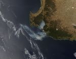

While floods soaked Queensland, Western Australia sizzled in late December 2010. Temperatures rose to more than 40 degrees Celsius (104 degrees Fahrenheit) in some areas, and hot, dry conditions likely set the stage for this wildfire that broke out along the coast west of Pemberton.
The Moderate Resolution Imaging Spectroradiometer (MODIS) on NASA’s Aqua satellite captured this natural-color image on December 29, 2010. Red outlines indicate hot spots where MODIS detected the unusually high surface temperatures associated with fire. Smoke plumes extend both north and south, suggesting that winds shifted direction after the fire started.
The Australian Associated Press reported that high temperatures plagued Western Australia over the Christmas holiday and continued for days afterward, prompting authorities to enact fire bans in some areas. The region around Perth (just north of the area pictured here) was especially hard-hit.
References & Resources
- Australian Associated Press. (2010, December 27). Perth swelters through 40-degree heat. The Sydney Morning Herald. Accessed December 29, 2010.
- Cairns Post. (2010, December 27). Rain floods east, west parched. Herald Sun. Accessed December 29, 2010.
NASA image courtesy Jeff Schmaltz, MODIS Rapid Response Team at NASA GSFC. Caption by Michon Scott.