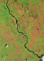
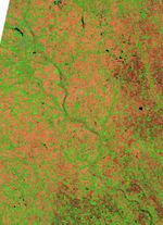
A tributary of the Missouri River, the James River experienced significant flooding in the spring of 2011. In early June 2011, the river was high enough to fill the river valley near the town of Mitchell, South Dakota.
The Thematic Mapper on the Landsat 5 satellite captured these images on June 5, 2011 (top), and May 19, 2005 (bottom). The June 2011 image shows flooded conditions, and the May 2005 image shows more normal conditions.
The images are rotated and north is at left. In these false-color images, water is navy blue. Depending on land use, areas above water are green, burnt orange, or orange-red. The town of Mitchell sports a grid pattern typical of urban areas. Outside of town, rectangular shapes indicate agricultural land.
In 2005, the thin James River takes a meandering path through the river valley. In 2011, however, the river has widened to perhaps 1 kilometer (0.6 miles) in places. Areas of standing water appear east of the river (top half of image), and tributaries to the James River are more prominent than usual.
Major flooding had already occurred near several communities along the James River in early April 2011. Two months later, the river was at moderate flood stage near those same communities. On June 7, 2011, the Advanced Hydrological Prediction Service of the U.S. National Weather Service reported that the James River reached 20.91 feet (6.37 meters) at 2:45 p.m. local time near Mitchell.
References & Resources
- National Weather Service. Advanced Hydrologic Prediction Service. Accessed June 7, 2011.
NASA Earth Observatory image created by Jesse Allen, using Landsat data provided by the United States Geological Survey.