


![Request for Information – Potential [Placeholder for Prize]](https://assets.science.nasa.gov/dynamicimage/assets/science/psd/solar/2023/09/s/solarsystem_0.jpg?w=1024)


February 6, 2012
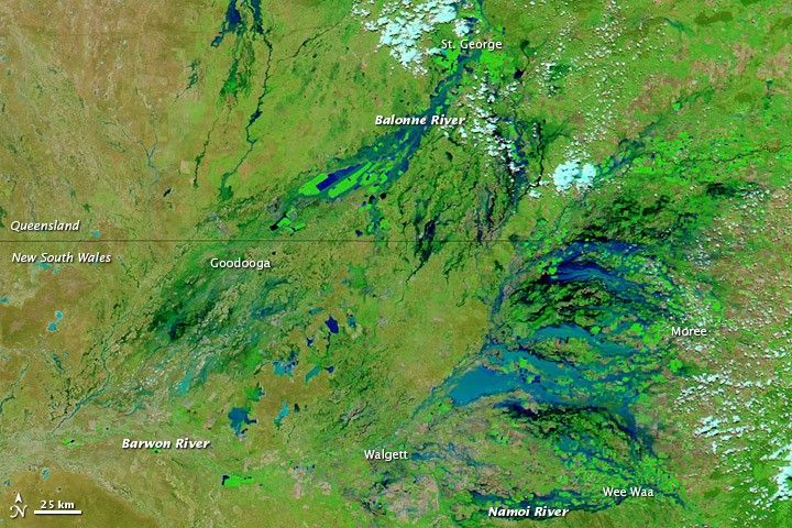
Flooding in Southeastern Australia
Severe flooding affected multiple communities along Australia’s Queensland-New South Wales border in early February 2012. The Australian Associated Press reported on February 5 that several thousand residents were isolated and cut off by a “virtual inland sea.”
The Moderate Resolution Imaging Spectroradiometer (MODIS) on NASA’s Terra satellite captured the top image on February 6, 2012. For comparison, the bottom image shows the same region on January 3, 2012. These images use a combination of visible and infrared light to better distinguish between water and land. Water varies from electric blue to navy. Vegetation is bright green. Bare ground is earth-toned. Clouds are pale blue-green.
A network of permanent and impermanent rivers stretches through this part of Australia. The Balonne, Barwon, and Namoi are all tributaries of the Darling River, which flows toward the southwest through New South Wales. Water actually appears higher in the Barwon River in early January than it does a month later. But almost all the other watercourses hold much more water in February, especially west of Moree and Wee Waa.
The Australian Associated Press reported that flood waters had receded from Moree by February 5, enabling residents to return home. The community of Walgett, however, was bracing for the arrival of flood waters, and residents of Wee Waa and Goodooga were among those isolated by the inland sea. Meanwhile, ABC News Australia reported that mandatory evacuations had been ordered for St. George, as authorities anticipated record flooding along the Balonne River.
References & Resources
- ABC News Australia. (2012, February 5). Residents ordered out as record flood looms. Accessed February 7, 2012.
- Australian Associated Press. (2012, February 5). Floods move downstream from Queensland to swamp inland towns in NSW. The Australian. Accessed February 7, 2012.
NASA images courtesy LANCE/EOSDIS MODIS Rapid Response Team at NASA GSFC. Caption by Michon Scott.


