March 5-29, 2025
Floodwaters Surge Through the Australian Outback
Heavy rainfall in Queensland sent floodwaters sweeping across vast stretches of the Australian outback in late March 2025. More than a year’s worth of rain fell in one week in some places. The deluge caused major flooding along multiple rivers in Channel Country, submerging small towns and grazing lands in southwestern Queensland.
While some portions of the flooded area remained obscured by clouds in late March, the OLI (Operational Land Imager) on Landsat 8 captured this mostly clear view of Cooper Creek near the town of Windorah on March 29 (right). For comparison, the left image, acquired by the OLI-2 on Landsat 9, shows the same area on March 5, before the intense rains. Both images are false color to emphasize the presence of water.
As waters rose, helicopter evacuations were organized for residents of Windorah and Jundah, a town about 75 kilometers (47 miles) upriver, according to news reports. Aerial photos showed settlements and pasturelands submerged, and government officials estimated that more than 100,000 livestock across Queensland may be missing or deceased.
In the week ending on March 29, parts of the state received more than 400 millimeters (16 inches) of rain. Floodwaters near Windorah, Jundah, and other towns rose to higher levels than those seen in 1974, a historic year for outback flooding and the wettest year on record in Australia. Inundated roadways may leave towns isolated for weeks, according to news reports.

It is typical for the Channel Country to undergo cycles of drought and flood, and wet periods can prompt growth in pasturelands, supply water to wetlands, and support endemic species. Experts have remarked, however, that the rain and floods in March 2025 have been extreme. They cite several factors for the rain, including streams of humid air from the north and east that converged over interior Queensland. A low-pressure trough drove the moisture-laden air to higher and cooler levels of the atmosphere to trigger the heavy rain.
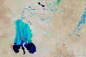
Flooding was widespread across western Queensland, with waters submerging thousands of kilometers of road, the AFP reported. The MODIS (Moderate Resolution Imaging Spectroradiometer) on NASA’s Terra satellite captured an image (above) of some of the affected area on March 29, 2025. In this false-color image, water appears dark and light blue; bare ground is brown; and vegetation is bright green.
Over the coming weeks and months, the water will drain toward Lake Eyre (also called Kati Thanda-Lake Eyre), about 600 kilometers southwest of Windorah. The lake sits at the lowest natural point in Australia and is dry most of the year. Every few years, some water flows all the way to the lake, but it is rare for it to fill completely. Following unusually abundant rain in 2019, the Australian Bureau of Meteorology estimated that 80 percent of the lake’s area ultimately became covered by water.
References & Resources
- ABC (2025, March 28) Outback chopper airlift takes 25 to safety as Qld floods emergency grows. Accessed April 2, 2025.
- ABC (2025, April 1) More than 100,000 head of livestock estimated lost during flooding in outback Queensland. Accessed April 2, 2025.
- Australian Bureau of Meteorology (2025) Rainfall update. Accessed April 2, 2025.
- The Conversation (2025, April 1) Torrential rains created devastating inland seas in outback Queensland. Soon, they will fill Kati Thanda-Lake Eyre. Accessed April 2, 2025.
- The Guardian (2025, March 31) Outback deluge pushes Queensland towns to the brink: ‘Out here it’s drought or floods’. Accessed April 2, 2025.
- NASA Earth Observatory (2018, March 29) Rivers Swell in Channel Country. Accessed April 2, 2025.
- NASA Earth Observatory (2020, August 2) Cooper Creek, Australia. Accessed April 2, 2025.
NASA Earth Observatory images by Michala Garrison, using Landsat data from the U.S. Geological Survey and MODIS data from NASA EOSDIS LANCE and GIBS/Worldview . Story by Lindsey Doermann .