
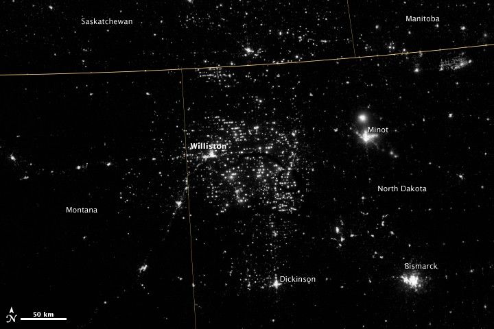
Northwestern North Dakota is one of the least-densely populated parts of the United States. Cities and people are scarce, but satellite imagery shows the area has been aglow at night in recent years. The reason: the area is home to the Bakken shale formation, a site where gas and oil production are booming.
On November 12, 2012, the Visible Infrared Imaging Radiometer Suite (VIIRS) on the Suomi NPP satellite captured this nighttime view of widespread drilling throughout the area. Most of the bright specks are lights associated with drilling equipment and temporary housing near drilling sites, though a few are evidence of gas flaring. Some of the brighter areas correspond to towns and cities including Williston, Minot, and Dickinson.
The image was captured by the VIIRS “day-night band,” which detects light in a range of wavelengths from green to near-infrared and uses “smart” light sensors to observe dim signals such as gas flares, auroras, wildfires, city lights, and reflected moonlight. When VIIRS acquired the image, the Moon was in its waning crescent phase, so the landscape was reflecting only a small amount of light.
According to the U.S. Energy Information Administration, natural gas production from the Bakken shale has increased more than 20-fold between 2007 and 2010. Gas production averaged over 485 million cubic feet per day in September 2011, compared to the 2005 average of about 160 million cubic feet per day. Due to the lack of a gas pipeline and processing facilities in the region, about 29 percent of that gas is flared.
Learn more about the VIIRS day-night band and nighttime imaging of Earth in our new feature story: Out of the Blue and Into the Black.
Further Reading
- Lee, T. (2006, Feb). The NPOESS VIIRS Day/Night Visible Sensor. Bulletin of the American Meteorological Society.
- Miller, S. (2012, Aug. 10). Suomi Satellite Brings to Light a Unique Frontier of Nighttime Environmental Sensing Capabilities. Proceeding of the National Academy of Sciences.
- NASA (n.d.) Suomi NPP. Accessed Nov. 29, 2012.
References & Resources
- NASA (n.d.) Suomi NPP. Accessed Nov. 29, 2012.
- U.S. Energy Information Administration (2011, Nov. 23) Over One-Third of Natural Gas Produced in North Dakota is Flared or Otherwise Not Marketed. Accessed Nov. 29, 2012.
NASA Earth Observatory image by Jesse Allen and Robert Simmon, using VIIRS Day-Night Band data from the Suomi National Polar-orbiting Partnership. Suomi NPP is the result of a partnership between NASA, the National Oceanic and Atmospheric Administration, and the Department of Defense. Caption by Adam Voiland.