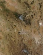
Arizona’s Horseshoe Two fire was burning along two distinct fronts on June 14, when the Moderate Resolution Imaging Spectroradiometer (MODIS) on the Terra satellite took this image. Red outlines the active fire regions, from which two plumes of smoke rise. The newly burned land between the fires is dark brown.
The Horseshoe Two fire has burned 171,333 acres (693 square kilometers or 268 square miles) of mixed forest, brush, and grass in southeastern Arizona and is 60 percent contained. The fire is threatening Chiricahua National Monument, forcing the park to close. The large image, which includes a larger area, also shows the Wallow Fire to the north and another large wildfire in northern Mexico.
References & Resources
- InciWeb. (2011, June 14). Horseshoe Two. Accessed June 15, 2011.
NASA image courtesy Jeff Schmaltz, MODIS Rapid Response Team at NASA GSFC. Caption by Holli Riebeek.