


- August 2 Quicktime (.mov) format (3.5 MB)
- August 2 MPEG-1 (.mpg) format (1 MB)
- August 3 Quicktime (.mov) format (2.3 MB)
- August 3 Quicktime (.mov) format (732 KB)
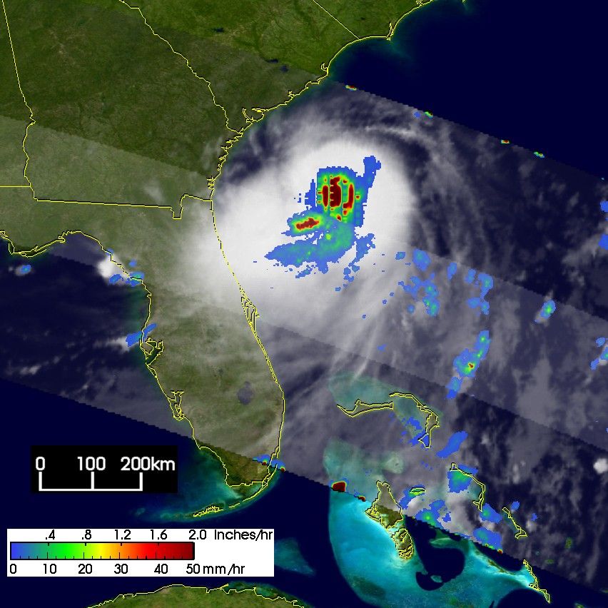
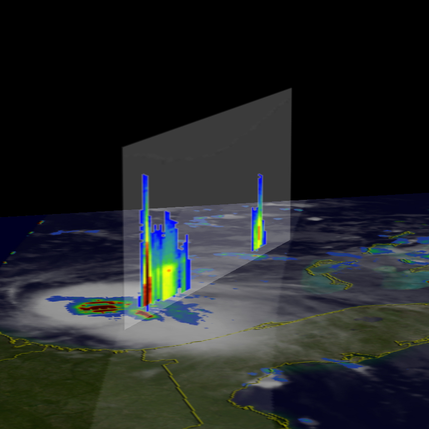
Alex, the first named storm of the 2004 Atlantic hurricane season, hasreached hurricane strength just off of the east coast of the US. Thestorm is expected to pass very close to the outer banks of North Carolinaduring the day (local time) on Tuesday the 3rd of August 2004. TheTropical Rainfall Measuring Mission or TRMM satellite was able to capturethese unique images of Alex as it organized off of the southeast US coast.The images and data obtained from TRMM can provide precise estimates ofthe storm's location as well as estimates of the storm's intensity to thethe National Hurricane Center (or NOAA Tropical Prediction Center). Thefirst image was taken at 08:23 UTC (04:23 EDT) on 2 August 2004. It showsthe horizontal distribution of rain intensity. Rain rates in the centerswath are from the TRMM Precipitation Radar (PR), the first and onlyprecipitation radar in space. The PR is able to provide fine resolutionrainfall data and detailed vertical structure. Rain rates in the outer swathare from the TRMM Microwave Imager (TMI). The rain rates are overlaid oninfrared (IR) data from the TRMM Visible Infrared Scanner (VIRS). At the timeof this image, Alex was still a minimal tropical storm with maximum sustainedwinds estimated at 35 knots (40 mph) by the National Hurricane Center. Theimage shows several areas of very heavy rain (dark red areas) near thecenter of Alex. Although the storm does not have an eye at this time, theseheavy rain rates are helping to fuel the storm. As water vapor condensesinto cloud droplets (which are then converted into rain), heat is released.This heat known as latent heat is what drives the storm's circulation. Itis most effective when it occurs near the center of the storm. The nextimage was taken at the same time and shows a vertical slice through thecenter of the Alex by the PR looking east. It shows a deep convectivetower almost 13.5 km high with very heavy rain protruding up through thefreezing level (vertical dark red area). The freezing level is apparentby the horizontal bright band near the top of the moderate rain (yellow)area to the right of the tower.
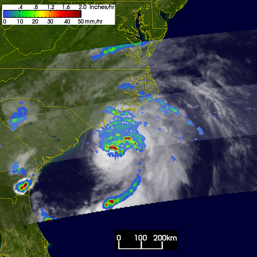
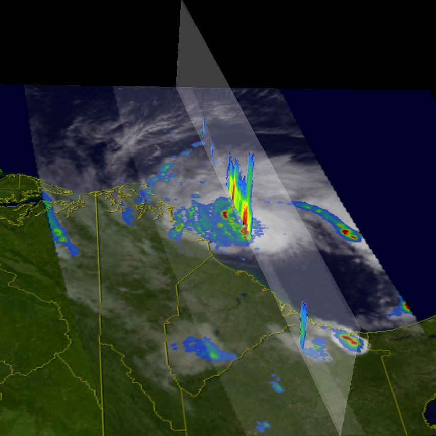
The next image was taken almost a day later at 04:12 UTC (00:12 EDT) on the3rd. A partial eyewall is now evident north of the center by the semicircleof heavy rain (dark red area). TRMM reveals that the rain field associatedwith Alex is very asymmetrical with the bulk of the rain appearing north ofthe center (blue area). Some banding is also evident in the moderateintensity rain (green arcs). The final image shows another PR cross sectiontaken through the northern eyewall. The view is looking down towards theeast. It shows a very tall convective tower nearly 16 km high (verticalblue/green area) embedded in the northern eyewall. Tall convective towersare often associated with intensifying storms. These final two images weretaken just two hours before Alex became a hurricane.
Alex initially formed from a tropical depression that was spawned by an upperlevel low east of the Florida peninsula on the evening of 31 July 2004. Thedepression moved slowly northeast towards the coast of South Carolina andstrengthened to become tropical storm Alex the following day, the 1st ofAugust. Alex hovered east of Georgia the night of the 1st with very littleforward speed. Alex remained a tropical storm on the 2nd but did begin tostrengthen over the warm waters of the Gulf Stream and also began movingnortheast parallel to the Carolina coast before intensifying into a Category2 hurricane the next day on the 3rd.
TRMM is a joint mission between NASA and the Japanese space agency JAXA.
References & Resources
mages produced by Hal Pierce (SSAI/NASA GSFC) and caption by Steve Lang (SSAI/NASA GSFC), NASA's Tropical Rainfall Measuring Mission.


