Suggested Searches

1 min read

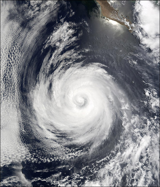
Hurricane Douglas South of Baja California

Instruments:
2024-07-23 12:00:00
July 23, 2002

As recently as July 23, 2002, Hurricane Douglas was a Category 2 hurricane, with winds as high as 90 knots (over 100 miles per hour). As of July 24, Douglas had dropped back to Category 1 status as it moved away from the Baja California Peninsula (seen at upper right) in the eastern Pacific Ocean. The storm is predicted to continue moving westward over the next 24 hours and should weaken as it moves over cooler waters. This image was acquired by the Moderate Resolution Imaging Spectroradiometer (MODIS) on the Terra satellite on July 23, 2002.

References & Resources

Image courtesy Jacques Descloitres, MODIS Land Rapid Response Team at NASA GSFC

You may also be interested in:

Stay up-to-date with the latest content from NASA as we explore the universe and discover more about our home planet.

Explosive Intensification for Hurricane Polo
5 min read

Several ingredients came together off the Pacific coast of Mexico to generate one of the strongest storms the eastern Pacific…

Article
Powerful Storms Continue to Prowl the Pacific
4 min read

Hurricanes Polo and Nolo sent destructive effects ashore amid an active season in the northeastern and central Pacific.

Article
Hurricane Simon Lurks Off the Mexican Coast
3 min read

Though it remained offshore, the storm lashed coastal areas with high winds and flooding—and produced remarkable rippling patterns in the…

Article